MADISON Strategic Plan
Part A. Background Report
MADISON Strategic Plan
Part A. Background Report

May 2018
Prepared by Randall Gross / Development Economics
Through a grant from The Memorial Foundation For All Together Madison and the Madison Community
NASHVILLE: 4416 Harding Place, Belle Meade 37205. Tel 202-427-3027 / Rangross@aol.com
WASHINGTON DC: 2311 Connecticut Ave Ste 206 20008. Tel 202-427-3027. Fax 332-1853. Rangross@aol.com AFRICA: African Development Economic Consultants (ADEC). 27-11-728-1965. Fax 728-8371. Randall@ADEC1.com UK: 118 Hampstead House, 176 Finchley Road, NW3 6BT London. Tel 44-79 0831 6890. rangross@aol.com
INTRODUCTION
A Strategic Plan has been prepared for the community of Madison on behalf of Madison’s residents, businesses, institutions, and other key stakeholders. This plan is the initiative of a grassroots, community-based coalition (All Together Madison ATM) in collaboration with other Madison organizations and Metro Nashville Government agencies. Funding for this initiative was secured through a grant from the Madison-based Memorial Foundation and from two private contributors. Members of ATM and a project steering committee helped guide the process undertaken by the consultant.
Purpose
Madison is part of Metro Nashville. If Madison were incorporated as a municipality, it would be the 17th largest city in Tennessee, with more than 40,000 residents. Residents see a need for economic development and revitalization, while at the same time, preserving Madison’s relative affordability in the face of rapid growth in the broader Nashville region. Previous plans and studies in Madison examined physical issues and provided infrastructure and development recommendations. However, they lacked the benefit of market and economic analysis to help underpin strategic recommendations.
The Strategic Plan examines socio-economic issues and forecasts real estate market potentials. Based on in-depth analysis and community stakeholder guidance, opportunities are identified for revitalization and development while enhancing the quality of life for Madison residents in all income levels.
Components and Structure
In essence, this plan presents a Strategy for the Revitalization and Economic Development of Madison. It includes an assessment of existing conditions, key strengths and challenges. The plan also presents findings from economic and real estate market analysis forecasting Madison’s potential in terms of market-rate and affordable housing, office space, retail/commercial space and industrial uses. Community visioning and engagement fully informed the recommendations. Strategies are developed for marketing and identity branding, development, organizational structure, financing, management, community economic development and other components. An Implementation Action Plan provides a point-by-point guide to implementation with specific actions for funders, non-profit organizations, government agencies, residents, businesses, property owners, and investors.
It should be noted that this is not a physical development plan or master plan for development of Madison. Nor does it provide a zoning plan or proposal that requires approval by Metro Government or its Planning Commission. This plan is not funded by Metro Government but should help inform Metro agencies and provide useful information to guide investment. This strategy is not a plan for any specific organization or group of people. It is intended for use by all of Madison’s residents, businesses, property owners, investors, institutions, and others.
Report Structure
The Strategic Plan comprises of three separate volumes (“parts”) and an Executive Summary. Part A: Background Report presents information gleaned from community stakeholders and background research on the community’s history, challenges, opportunities, existing conditions, and competitive advantages. Section 1 of the Background Report provides an Existing Conditions Assessment while Section 2 provides a summary of input from stakeholder meetings, interviews, and presentations.
Part B: Market Analysis Report, provides a summary of findings on the existing and potential market for office, industrial, residential and retail uses within the Madison study area. Section 1 presents findings on Office, Section 2 Industrial, Section 3 Residential, and Section 4 Retail. An overall summary of market findings is provided in the final section of this Part B Report.
Part C: Strategic Implementation Plan. Part C provides the recommended strategies for economic development and revitalization of Madison, relating to marketing and identity branding, development, organizational structure, financing, management, community economic development and other components as noted earlier. Part C also provides a 3-5 year Implementation Action Plan matrix that identifies the specific tasks and timetables, assigns responsibility, and generates indicative costs and proposed funding sources for each of the listed tasks.
Acknowledgements
The consultant wishes to acknowledge the tireless grassroots efforts of the community and members of All Together Madison, under the leadership of Sasha Mullins-Lassiter and Mark North. Also recognized are the contributions of the various Madison organizations including the Madison-Rivergate Chamber of Commerce, Discover Madison, Madison 360, and others as well as churches, schools, and other institutions. The work could not have been possible without the financial contributions and support of The Memorial Foundation and several private individuals. Finally, the many residents, businesses, property owners and investors in Madison who participated in this strategic planning process over a two-year period provided the vision, input, and inspiration for recommendations contained herein. Key acknowledgements are detailed below.
 Initiative
- All-Together Madison (ad hoc community-based coalition)
Funding
- The Memorial Foundation: Scott Perry, President
- Anonymous and Ross Cortese, private contributors
Strategic Steering Committee
- Madison Residents
- Representatives of key Madison organizations & funders
- Civic & religious institutions
- Business and real estate interests
- Ex Officio: Elected officials and Metro agency staff
Consultants
- Randall Gross / Development Economics
- Ben Johnson Illustrations (Conceptual renderings)
Advisory, Design, and Logistical Support
- Gresham Smith
- Nashville Civic Design Center
Madison Organizations
- Discover Madison
- Madison-Rivergate Chamber of Commerce
- Madison 360
Political Representatives
- Anthony David, Metro Council District 7
- Brenda Haywood, Metro Council District 3
- Doug Pardue, Metro Council District 10
- Bill Pridemore, Metro Council District 9
- Nancy VanReece, Metro Council District 8
- Jill Speering, School Board District 3
- Bill Beck, Tennessee State Representative
- Brenda Gilmore, Tennessee State Representative
- Thelma Harper, Tennessee State Representative
- Bo Mitchell, Tennessee State Representative
- Steve Dickerson, Tennessee State Senator
- Jeff Yarbro, Tennessee State Senator
Metro Government Agencies
- Mayor’s Office
- Metro Arts Commission
- Metro Development & Housing Agency
- Metro Planning
- Metro Public Works
- Metro Schools
- Metro Transit Authority
Section 1. EXISTING CONDITIONS ASSESSMENT
This section provides findings from an assessment of existing physical, demographic, and socio-economic conditions in Madison. A discussion of Madison’s location, transportation access, history, culture, economy, demographics, and physical conditions help provide context for economic development and for addressing key issues identified as part of this strategic planning process. A site analysis also provides input to market and economic analyses discussed in the Part B Report.
Location and Study Area
For the purposes of this Strategic Plan, Madison was defined by All Together Madison (ATM) as the portion of Metro Nashville bound on the south by Briley Parkway, on the east by the Cumberland River, on the north by Sumner County, and on the west by I-65. In addition, some consideration was also given to areas west of I-65 to Dickerson Pike.
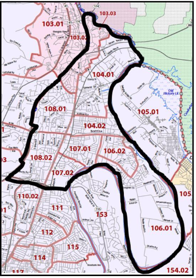
For assessment of the demographic base, the Study Area includes Census Tracts 103.03, 104.01, 104.02, 106.01, 106.02, 107.01, 107.02, 108.01, and 108.02. Tract 103.03, which lies east of I-65, is a small portion of the City of Goodlettsville that includes RiverGate Mall. Much of Madison also correlates to the boundaries of Zip Code 37115. Overall, this area represents a significant portion of Metro Nashville-Davidson County
Political Boundaries
Madison is an unincorporated place that forms part of Metro Nashville. As such, it has no independent municipal government functions, despite its large size and distinct history as a community. In addition, Madison is represented by no less than five (5) council seats in the Metro Nashville Council, so its local political representation is highly disaggregated. Further, four of these five council districts cover neighborhoods outside of Madison, so they are not dedicated to solely represent Madison’s interests at Metro Government.
- District 7 includes portions of East Nashville, Inglewood, and a small part of Madison east of Gallatin Pike.
- District 8 includes Inglewood and Madison, west of Gallatin Pike.
- District 9 includes the Neely’s Bend and Myatt Drive portions of Madison, east of Gallatin Pike. This is the only Council District located wholly within Madison.
- District 10 includes the northern portion of Madison-RiverGate, as well as Goodlettsville and Ridgetop.
- District 3 includes the Bellshire area west to Whites Creek and north to Ridgetop. While not technically within the Study Area, some associate portions immediately west of I-65 and north of Old Hickory Boulevard with Madison.Downtown Madison is split between Districts 8 (west of Gallatin Pike), 9 (east of Gallatin Pike, north of Neely’s Bend), and 7 (east of Gallatin, south of Neely’s Bend). This political divide adds to the challenge of developing and implementing a comprehensive vision for downtown Madison.
Service Area Boundaries
Portions of Madison that were formerly located within Metro’s General Services District (GSD) were recently added to the Metro Urban Services District (USD). The USD provides a higher level of urban services including trash pickup, sidewalks, street lights, sewer, and stormwater service. While much of Madison already had some of these services, the extension of USD into the area formalizes maintenance and budgeting for these services. That being said, some portions of Madison still reside outside of the USD, including most of Neely’s Bend (southeast of Larkin Springs), RiverGate (north of Dry Creek), and Graycroft (north of Apple Valley Road/1-Mile Parkway). On the west side of I-65, the USD extends only to Old Hickory Boulevard. In general, the USD includes most of Madison, aside from Neely’s Bend and RiverGate.
Neighborhoods
Madison is a broad geographic area that includes a number of individual neighborhoods, subdivisions and multi-family or senior housing developments. Google Maps identifies the following “neighborhoods” in Madison, although some are merely names on the map:
Walton Oaks, Fawnwood, Ellington Place, Oakland Trace, Oakland Acres, Imperial Manor, Pleasant Acres, Holiday Hills, Blair Estates, Blair Heights, Hickory Gardens, Heritage House, Williams Valley, Haven Acres, Morning View, Heritage Square, Castle Grove, Bonnie Brae, Primrose Acres, Primrose Meadows, Graycroft/Graybrook, Alta Loma, Montague, Chippington Towers, Berkely Hills, West Montague, Maybelle Carter, Falcon View, Covington Place, Madison Park, Crittenden Estates, Robin Hood, Forest Park, Lanier Park, Rothwood, Rainbow Terrace, Madison Heights, Kingsway Green, Arrowhead Estates, River Retreat, Cumberland View Towers, Cheyenne Trace, Heron’s Walk, Meadow Bend, Candlewood, Schoolside Heights, Canton Pass, Cumberland Station, Neelys Bend Villas, Kimbolton, Marlin Meadows, Nashwood Park, Rio Vista, Archwood Acres, DuPont Avenue, Kennaston Estates, Madison Park, Woodlawn Estates, Lamplighter, Amqui Place, Cedarwood Courtyard, Shannon Place, Oakwood, Cumberland Bend, Eastlawn, Edgemeade Farms, Crestbrook Meadows, Edenwold City, Harbor Village, Enclave at Twin Hills, Shepherd Hills, Carestone, Churchill Crossing, Bristol Park at Riverchase, and Mansker Meadows.
Organizational Structure
Because Madison does not have its own local government structure, and its representation in the Metro Council is highly disaggregated, local non-profit organizations that represent Madison’s interests thereby become more relevant and important to ensure that Madison retains some control over its future. Despite the presence of active organizations in the past (Chamber of Commerce, Pro Madison, Madison Merchants’ Association, etc), the area today lacks a strong and cohesive network of organizations with the capacity, mission, or structure to implement critical projects or programs. However, there are several organizations with impassioned leadership and a renewed sense of purpose to help revitalize the community. These organizations include the following:
Madison-Rivergate Chamber of Commerce
The longest-running of the local organizations, the Madison-Rivergate Chamber of Commerce has worked for decades to promote Madison as a center for business and commerce. The Chamber, which is registered as a 501(c)6 has recently undergone a transformation with the departure of its long-term director under a cloud of controversy. A new Executive Director has been appointed by the Chamber Board to re-establish a positive image for the Chamber and strengthen its mission in the community. Ultimately, as a Chamber, that mission relates primarily to representing and promoting Madison’s local businesses. The Chamber also brings residents and businesses in Madison together through annual events that celebrate the community’s heritage.
Discover Madison (Amqui Station)
State funding for restoration of historic Amqui Station resulted in the establishment of Discover Madison, an organization charged with maintaining the facility. The mission of Discover Madison is also oriented to attracting visitors to the station and to Madison, and educating residents and visitors alike on Madison’s unique history. This organization has also emerged from a recent transition, with the departure of its director and re-establishment of its board.
All Together Madison
All Together Madison (ATM) is essentially an “ad hoc” group established by a community activist to help guide this Strategic Plan. The group has also become a sounding board for various community engagement processes. ATM has no legal structure or governing board, no set mission or strategic plan. But ATM has also accomplished a great deal in a short time for a group without any legal designation.
Madison 360 & Other Business Associations
Madison 360 is another group without any legal status but has been successful to date in communicating with local businesses and bringing them together for networking and support. Several other ad hoc groups have formed or are also forming in Madison, primarily to represent businesses.
Fifty Forward
Fifty Forward is a regional service provider for adults 50 years and older, offering innovative programs and services through its Madison Station Active Lifestyle Center, located adjacent to Amqui Station at 301 Madison Street. Programs include continuing education, wellness, Living at Home services, performing arts, travel, recreation activities and other services.
Neighborhood Associations
There are a number of existing neighborhood-based organizations including neighborhood watch groups as well as homeowners associations and organizations with a broader purpose of representation and neighborhood improvement. Among the organizations identified based on information from the Nashville Neighborhood Alliance are the following:
Neighborhood Organizations & Homeowners Associations
- Arrowhead Estates Neighborhood Association
- Bonnie Brae Subdivision Community Council
- Candlewood Homeowners Association
- Harbor Village Homeowners Association
- Heritage Square Homeowners Association
- Montague Neighborhood Association
- Neely’s Bend Neighborhood Association
- Shepherd Hills Neighborhood Association
- Walton Oaks Neighbors
Apartment Resident Associations
- Alta Loma Apartments
- Heritage House Apartments
Neighborhood Watch Groups
- Amqui Station
- Crestview Meadows Condo
- Cumberland Station
- East Madison
Transportation Access & Exposure
Madison is centrally-located within the northern half of the Nashville Metropolitan Statistical Area (MSA), with excellent local and regional access via limited access routes (Interstate 65, Briley Parkway, Ellington Parkway, Vietnam Veterans Parkway) and major arterial thoroughfares (Gallatin Pike (U.S. Highway 31E), Old Hickory Boulevard (State Route 45), and Dickerson Pike (U.S. Highway 41). Good local access is also provided via Neely’s Bend Road, Myatt Drive, Graycroft Avenue, Saunders Avenue, and Due West Avenue.
Commuting Distances
Downtown Madison is just 9.5 miles or 18 minutes from Downtown Nashville, making it a desirable location for commuters as well as for residents accessing downtown restaurants and entertainment. Areas on the southern border of Madison near Nossi College of Art are located only seven miles or 10 minutes from Downtown Nashville. Madison is 15 minutes (12 miles) from Nashville International Airport, 16 minutes from Hendersonville (8 miles), and just 11 minutes (5 miles) from the Grand Ole Opry House, Opry Mills, and the Opryland Hotel & Convention Center. Thus, the community is very accessible and proximate to several major employment nodes in the region.
Traffic and Exposure
Interstate 65 in Madison carries 113,000 to 162,000 vehicles per day, according to TDOT’s 2016 Average Daily Traffic (ADT) counts. Thus, the interstate generates significant exposure for Madison on a daily basis. While traffic on Gallatin Pike has stagnated over time, I-65 traffic has nearly doubled over the same period, from around 60,000 in 1986. Clearly, regional north-south traffic is increasing (thanks in large measure to population growth in Sumner County), but commuters are choosing the interstate system over local roads and arterials.
Gallatin Pike is the region’s longest commercial corridor, extending more than 30 miles from the Cumberland River to Downtown Gallatin. Traffic and exposure for Madison is fairly high along Gallatin Pike. TDOT 2016 ADT counts on Gallatin Pike range from about 25,100 just south of Myatt Drive/Rivergate Parkway to 35,900 just north of Myatt Drive near RiverGate Mall. Gallatin Pike north of Briley Parkway has ADT of 32,300. In Downtown Madison (just south of Old Hickory Boulevard), Gallatin Pike has ADT of 27,900. These numbers all represent significant volumes for a local street and provide exposure for the commercial businesses that line this road. That being said, traffic counts have generally fallen over time since the 1980s, particularly around RiverGate Mall, and reduced traffic has impacted on business sales.
Briley Parkway is a major cross-town, limited access highway. The road carries 50,000 vehicles per day just east of I-65, with traffic increasing to 77,000 ADT each of Ellington Parkway and 87,800 ADT at the river. The interchange of I-65 and Briley has total traffic of about 212,000 vehicles per day generated by these two highways. Adding traffic from Ellington Parkway nearby brings the total to more than 260,000 vehicles per day. These combined interchanges may represent the busiest traffic node in Middle Tennessee, creating enormous potential exposure for Madison at this location.
Ellington Parkway carries 33,000 to 48,000 vehicles per day, which is comparatively modest number given that it is a limited-access highway that bypasses traffic on both I-65 and Gallatin Pike. Commuters have gradually noticed this advantage over time, and traffic on Ellington Parkway has increased by about one-third since the 1980s. South Graycroft Avenue, a local extension of Ellington Parkway towards the north, carries about 18,000 vehicles per day, which is relatively heavy for a two-lane local road. Other 2016 traffic counts generated by TDOT in Madison include the following:
- Old Hickory Boulevard: 20,000 (east of Gallatin) to 33,000 (west)
- Rivergate Parkway: 30,000
- Myatt Drive: 20,000-22,000
- Dickerson Pike: 13,000-21,000
- Conference Drive: 19,000
- Neely’s Bend Road: 11,000-14,000
- Due West Avenue: 13,000
- Anderson Lane: 5,000
- Alta Loma Road: 3,800
- Randy Road: 3,000
Bottlenecks and Congestion
Community members have identified issues with traffic volumes and bottlenecks, particularly at Neely’s Bend and Gallatin Pike, and within Downtown Madison. Improvements planned for the extension of Neely’s Bend (“Station Boulevard”) connecting to Old Hickory Boulevard are aimed in part at alleviating some of these congestion issues.
Public Transportation
Madison has good, well-utilized bus service including a BRT “Light” bus line along Gallatin Pike to Downtown Nashville. Bus routes 26 and 56 (BRT) provide direct service from Rivergate to Downtown. Other key routes include Route 76 through Neely’s Bend and Old Hickory Boulevard, Route 34 travels Briley Parkway and south on Ellington Parkway. The Route 36X bus from Downtown Madison travels south along Graycroft and connects to Downtown via Ellington Parkway. Route 27 connects Madison to Old Hickory and south to I-40. Meanwhile, routes 35X, 87X and 92X carry passengers south from Rivergate on I-65 towards Downtown Nashville.
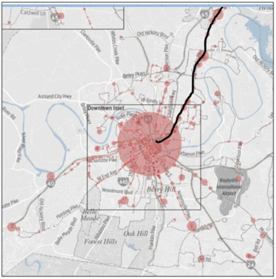
The Gallatin Pike Corridor bus routes recorded 1,137,794 trips during 2017, the highest by far of any transit corridor in Davidson County. The next highest ridership was the Murfreesboro Pike Corridor, with 974,020 trips or about 15% less ridership than the Gallatin Pike Corridor.
Historical and Cultural Overview
The Madison area has a long and proud history separate from, and inter- connected with, that of the rest of Nashville. While the purpose of this Strategic Plan is not to document every detail from the rich history of Madison, it is important to discuss the highlights in order to provide context for understanding Madison today and to celebrate and strengthen its unique identity as we plan for the future. Unless otherwise noted, portions of the following historical overview is gleaned from information contained in the book, Madison Station, written by Guy Alan Bockmon and published by Hillsboro Press in 1997.
Natural Resources and Early Hunters
Before European settlement, the area that now comprises Madison provided a wealth of natural resources including salt “licks” along the Cumberland River that attracted herds of bison and other large mammals. Neely’s Lick was located at a sulphur spring, later named Larkin’s Spring after property owner Thomas Larkin. Larkin’s Spring became a popular place for bottling water in the early 20th century until Prohibition shut off the market for sulphur water as a “cure” for hangovers. Not surprisingly, the area became valuable hunting grounds for various early nations in this region, including the Cherokee. An area near the old Depot Lane (now Madison Street) has been identified as the possible site of an early American Indian settlement. Paths worn by bison (“Old Trailbreaker”), other large game animals, and early hunters gradually became trails for walking, hunting, and transportation by European American settlers with names like Mansker, Spencer, Buchanan, Craighead, and Love. Bockmon notes that busy Gallatin Pike originated as a humble bison path (“Old Trailbreaker’s Trace”) through virgin forests.
European Settlers
An early frontier outpost “Fort Union” may have been located near what is now Spring Hill Cemetery, and 18th century land grants subdivided huge areas near Love’s Branch (between Old Hickory Boulevard and McGavock Pike) for families including Scott, Cocke, Buchanan, McLean, Evans, Carvin and Dunham. Isaac Neely was another early settler, namesake for Neely’s Bend. Robert Hays, Thomas Overton, John Overton (Andrew Jackson’s law partner), and James Cole Montflorence joined a partnership for the manufacture of salt at Neely’s Lick. Violence reigned as settlers encroached on Cherokee hunting grounds. The Neelys’ daughter, Mary, was apparently taken prisoner by Cherokee around 1780, then escaped in Indiana disguised as a man and taken (again) as prisoner of war by the British. She later married George Speers and finally returned to Neely’s Bend in the 1840s.
Also in the 1780s, Presbyterian minister Thomas Brown Craighead led a group of about 20 families of Irish descent from Washington County, Virginia to preach and establish a church, and to build one of the region’s first schools (known as the Spring Hill Meetinghouse), located on the Buchanan land grant in Madison. Among the many contributors to Craighead’s school was Colonel James Robertson, a founder of Nashville. In 1806, the “Academy of Davidson County” was relocated from Spring Hill closer into Nashville and incorporated into Davidson College (later the University of Nashville). “Irish Station,” the community’s enclave, was located near Haysborough, just north of what is now Briley Parkway along the Cumberland River. A memorial to the Spring Hill Meetinghouse is located in the southwest corner of Spring Hill Cemetery.
Haysborough
In 1794, Colonel Robert Hays sold more than 300 acres along the Cumberland River. About 40 of those acres would be subdivided into 72 1⁄2-acre lots (each sold for $10). In 1802, the State General Assembly named Haysborough (later known as “Haysboro”) as an inspection point for hemp because it offered portage and harbor. By 1804, the village had about 20 houses. The first retail business in Madison, John Coffee’s Store (a “typical” country store), was established in Haysboro in 1802. Bockmon quotes Harriet Simpson Arnow in describing the “heady mixture of odors” emanating from the merchandise in this store:
The faint smell of dye and paste in the felt chip bonnets was all but smothered under the leathery, oily smell of new saddles and bridles; this in turn competing with the odors of New England cheese, vinegar, freshly broached keg of port or Madeira, and barrel of whiskey…chewing tobacco, ginger, nutmeg, mace and cloves.”
Frequent social activities like balls were held in town. At one point, there were three stagecoach lines operating through Haysboro, connecting it north to Louisville, Frankfort, and Lexington. But the village had already begun to stagnate by the 1810s. Davidson Academy relocated from the area in 1806. Competition increased from Methodists and Baptists to the area’s Presbyterian ministry. Flooding in the area in 1800 and 1810 may have reduced interest in Haysboro’s real estate. And the Nashville and Gallatin Turnpike Company opened its gates in 1839 on a route that bypassed Haysboro. By that time, the village only recorded about six families.
19th Civil District and the Civil War
The boundary of the old Davidson County Civil (Court) District 19 aligned somewhat with the southern half of the study area defined for this Strategic Plan: south along what is now Briley Parkway, west along Louisville Branch Turnpike (Dickerson Pike) and north along Dry Creek to the Cumberland River (which formed its eastern edge).
Thomas Stratton, a 27-year old planter from Powhatan County, Virginia, settled in what is now Madison in 1806. His son, Madison, would in turn bear the community’s name. Among the prominent citizens of the area at that time were Colonel Robert Weakley, David Vaughn, William Williams, and Samuel Love. Most of the planters in the area owned slaves: Willis Swann owned 180 acres and 5 slaves, Rueben Payne had 300 acres and 15 slaves, Edmund Goodrich had 400 acres and 9 slaves, while Peter Bashaw had 195 acres and 4 slaves. By 1840, the district was still a fairly sparsely-populated area of 1,065 people and an average farm of 248 acres. There were 442 slaves. The wealthiest man in the district was John Overton, with 1,200 acres and 27 slaves. In 1848, City Road Chapel began in a structure located near Old Hickory Boulevard and Gallatin Road. By 1850, the number of slaves had increased to 579, even though the overall population had fallen by 33 to 1,032. Over 90% of the district’s population was engaged in farming.
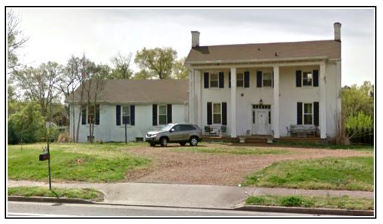 White men from these farms joined the “Cumberland Rifles,” C Company of the Tennessee Regiment in the Civil War. While Madison was not the scene of any major battles, its river, rail, and road assets were of paramount logistical importance to both sides and there were several skirmishes in 1862 near Neely’s Bend. Unlike other parts of Middle Tennessee, the 19th District’s farms remained relatively unscathed by the war, Edenwold and other antebellum homes intact. Most of these plantation homes were not demolished until the mid-20th century, such as when the Stratton home was razed for the construction of the Maybelle Carter
Retirement Center on Due West Avenue. “Glen Echo” was demolished for the entry ramp to Briley Parkway. “Evergreen” (located at 613 West Old Hickory Boulevard) may be among the only remaining antebellum-era homes in the Madison area.
After the war, freedman in the 19th District tended to become sharecroppers on existing farms. In 1870, more than 98.4% of the area’s black residents were 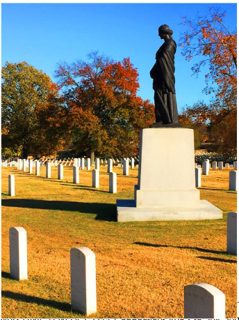 illiterate, since they had not had access to education as slaves. In 1869, M.C. Meigs wrote that land alongside Gallatin Turnpike and the L&N Rail Line was selected as the location for a new National Cemetery “so that no one could come to Nashville from the north and not be reminded of the sacrifices that had been made for the preservation of the Union.” A total of 16,486 soldiers were interred at the cemetery, including 1,909 black soldiers who died fighting in the war.
Emerging Transportation Hub
When the area was mapped in the 1870s, Madison was still a rural area located along the Gallatin Turnpike, a dirt transportation route which extended from the village of Edgefield (now a neighborhood in East Nashville) to Gallatin, Tennessee. Over the years, Gallatin Pike has been known successively as Old Trailbreaker’s Trace, a bridle path, Avery Trace, Walton Road, Jackson Highway, the Nashville-Lexington Road, and U.S. Highway 31E. Other early roads in the area included Neely’s Bend, Hudson Lane, Goodrich Road (now Due West Avenue), Hall Lane, and Hamblen (now Campbell) Road. Until the 20th century, property owners were required to physically maintain the roads in front of their property or suffer fines. Several boats ferried people and animals across the Cumberland into what is now Donelson. Neely’s Bend Road was among the early east-west roads through the area and a creek (Craighead’s Branch) ran under what is now Briley Parkway.
Madison Station. The Edgefield & Kentucky Railroad (which later merged with the Louisville and Nashville (L&N) Railroad) extended parallel to both Gallatin Turnpike and Louisville Branch Turnpike (Dickerson Pike). In 1850, Madison Stratton sold land used for the construction of the station which bore his name, on level ground to accommodate trains on both the E&K and L&N lines. The Madison Station Post Office was chartered at the newly-opened station in 1857. Madison Station operated as a depot on the L&N passenger line until 1935 (when it closed despite the fact that the Madison Station may have been the most “prosperous” in the L&N system).”
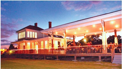 Other stations were also built nearby along the rail lines: Ekin Station (located near Walton at the National Cemetery) was built after the Civil War and Amqui Depot (pictured here) was constructed in 1910. Tracks of the two rail lines (E&K and L&N) met at a place along Dry Creek known as Edgefield Junction (today about halfway between downtown Madison and Rivergate). While Madison had 100 residents in the 1880s, Edgefield Junction had 400 residents.
An Interurban (trolley) line opened in 1913, connecting Downtown Nashville through Madison to Gallatin. Trolley lines were less expensive and more efficient for short commuter runs between the small towns and emerging urban neighborhoods around Nashville. Closed during the Great Depression, such lines could be considered a precursor to the “light rail” lines recently proposed along Gallatin Pike for future development.
Farms and Agriculture
After the Civil War, the average size of a farm in District 19 had fallen to just 59 acres. Despite growth in the number of farms, there were still 3,000 acres of woodlands around Madison Station in 1880. The Panic of 1873 (coupled with the cholera epidemic that followed) sent area farmers and their workers into an economic depression. Farm values fell precipitously and farm worker wages dropped to just $3.34 per week. After several years, agricultural production recovered in the area.
Even as late as the 1930s and ‘40s, Madison was comprised largely of farms and other agricultural enterprises. According to Bockmon, the area’s “mineral rich, loamy soil” and grasses helped support Madison’s many dairy farms producing milk and butter, as well as thoroughbred farming. Madison was part of the Bluegrass Region of Tennessee, which was as productive as Kentucky’s famous Bluegrass Region around Lexington. Pon’s bluegrass stock farm was a successful operation for many years. But strict religious dictates against gambling effectively killed the thoroughbred industry in Tennessee in the 19th century. W.O. Parmer’s Edenwold farm in north Madison was among the last great thoroughbred nurseries in Middle Tennessee. Madison’s Edenwold neighborhood derives its name from the old thoroughbred farm.
Commerce & Industry
As early as 1873, several business and institutional uses had clustered around what would become Madison Station, including Methodist and Presbyterian churches, Woodruff’s General Store, Sloan & Allen’s Marble Works, Baker’s Nursery, the “Little Red Schoolhouse,” and a small inn. Woodruff’s served as the community’s social center for several decades.
W.F. Gray relocated from North Carolina and opened the area’s first factory at the corner of Hall’s Lane and Gray Avenue in 1857. The company manufactured Gray’s Ointment (a highly successful cure-all and pain reliever), and propelled the company’s reputation as one of the oldest manufacturers in Tennessee, selling the “oldest remedy in the U.S.”
Grey’s concoction was made from turpentine, menthol crystals, pine tar, sassafras, carbolic acid, creosote, aluminum oxide, and zinc oxide. Sales spread throughout the nation through mail and parcel post delivery. The product was promoted by WWI soldiers as a cure for bunk lice: “Put on your old Grey’s Ointment…it burns and itches, but it kills those sons-a-…” The company was a fixture in Madison from 1860 through 1972, when its building was demolished for the Heritage House Apartments.
In the 1880 Census, area residents listed among their professions: farmers, laborers, tradesmen, servants, “hucksters,” fishermen, steamboat pilot, and banjo player. Immigrants began to arrive in the area from Germany, England, Scotland, Ireland, Prussia and Italy.
` Properties near Neely’s Bend Road and Madison Station were subdivided into smaller lots in 1880s and 1890s, suggesting the creation of a small unincorporated town. “Madison” at this stage had about 100 residents, a post office, doctor, justice of the peace, railroad agent, grocer, constable, live stock breeder, and dry goods store (Woodruff’s). As noted earlier, Edgefield Junction (which was later renamed Edenwold) expanded faster at first, with a grist mill, Roman Catholic & Baptist churches, 3 stores, and various service providers (blacksmith, telegraphers, carpenter, plasterer, wagonmaker, station agent, etc.
E. R. Doolittle acquired the Woodruff store in 1900, became Madison’s Postmaster and then started the community’s first bank – Madison Bank and Trust Company – in 1913. Doolittle helped form Madison’s Auxiliary of the American Red Cross to support the war effort in WWI. Also in support of America’s war efforts, the world’s largest powder plant was built and operated by the E. I. du Pont de Nemours Company across the river from Edenwold in Old Hickory. Madison served as a “bedroom community” to house some of the 17,000 workers who came to work at the massive plant, which received an average of 275 freight cars daily and frequent train service discharging workers at the Edenwold Ferry.
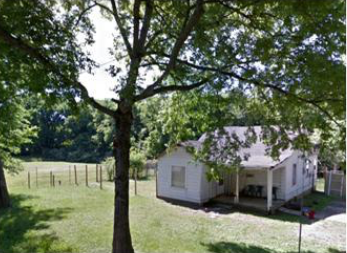 Real estate speculators helped construct Edenwold subdivisions with modest homes on streets named Shakespeare, Tennyson, and Scott (accidentally labeled “Scoot”) to support the workforce. Sometime later, houses were literally moved from Old Hickory to Madison.
Davidson County tried unsuccessfully to gain federal Government funding to build a bridge from Neely’s Bend Road across to Hadley Bend (Old Hickory). Nevertheless a temporary pontoon bridge was constructed to ease traffic flow across to the plant. With the war over by 1919, the urgency of building a bridge was less apparent. The huge powder plant ceased operations, although by 1923, it was called back online as a private Du Pont chemicals facility. The Old Hickory Boulevard Bridge would finally be constructed over the Cumberland River by the end of the Great Depression.
By the late 1930s, Madison had a number of businesses to serve its growing population base. Among those were the Stop & Shop grocery, Old Hickory Ice & Coal, Gamble’s Ford dealership, McClure Furniture, Doochin’s 5 & 10-Cent Store, Madison Bank & Trust, Piggly Wiggly, Lovely Pharmacy, Kornman’s Department Store, Hewitt’s Food Store, Meyer’s & Sons Department Store, Madison Theatre, Garrett’s Pharmacy, David Billiard & Pool Room, Armour’s Barber, Herndon Cleaners, Bill Vaughn auto dealer, McNish Lumber Yard and others. Madison Theater was described as a “handsome picture show house…Tennessee’s newest and most modern theatre.”
A “Madison Community Fair” was promoted in 1936 by the Madison News, a community newspaper that focused on social news and on clubs like the Civic Club, Big Brothers, Garden Club, Sewing Club, and various missionary and religious clubs. In 1941, the Odom family began producing and distributing sausage “loaded into an old Chevy, minus its back seat.” Madison’s Odom Sausage Company, home to “Tennessee Pride Country Sausage,” grew into one of the largest meatpacking operations in the South. The company began acquiring land in 1949 to build a large plant at 1201 Neely’s Bend Road. Few can forget the company’s famous advertising jingle “For real country sausage, the best you ever tried, look for me on the label of Tennessee Pride…Take home a package of Tennessee Pride!”
 In 1953, local businesses formed the Madison Chamber of Commerce to boost the community’s growth, urging all businesses and professionals to join and “take an active part in helping Madison become the leading, modern town in the country.” A separate Neely’s Bend Chamber also operated for a while. The short-lived Madison Country Club was organized in 1945 and Tom Singer’s private Madison Airport began operations (including flying lessons) at the former (ca 1855) Smith Gee residence along the Cumberland River at Neely’s Bend Road in 1946. In 1948, Madison was promoted through the Nashville real estate board as “Nashville’s Largest Suburban Area, Population 8,000…The Pleasant City Out in the Country that Gives You a Cordial Welcome.” Madison was further promoted as being located at the center of a “prosperous bluegrass farming section… with clean air, bright homes, excellent modern stores…charming.” Horse shows were held at the Stratton School ring.
In 1954, Madison had two (community-supported) police departments, two banks, and two clinics, many grocery and dry goods stores, flower shops, shoe shops, hardware stores, drug stores, jewelry and novelty stores, three theaters (including a drive-in), and various other businesses like the popular Draper’s Home Supply Store.
Most urban services were funded through contributions from residents and businesses. Households each made $1 contributions per month through a “subscription service” to support the local police (added to the level of service provided by the County Sherriff) and were asked to cut and maintain the grass along streets in their neighborhoods. Despite the presence of added safety officers, Madison suffered some problems with crime and vice (bootlegging and gambling) after WWII. Businesses were asked to contribute to the cost of street lights along Gallatin Road (celebrated through a “Festival of Progress”) and the
Civic Club (later replaced by the Kiwanis Club) funded purchase of a fire engine for a new Volunteer Fire Department. Montague constructed its own fire station and space for a “teen town” activity center. A “Community Chest” was established to fund social causes. Still, the community lacked a sewerage system, traffic lights, sidewalks and curbs, business zoning laws, and other urban amenities and services.
Madison Square Shopping Center, one-third larger in size than the new Green Hills Shopping Center and “one of the largest in the south” was opened in 1956. A crowd enthusiastically estimated at 75,000 attended the grand opening, where the streets were paved with candy and pink poodles did tricks. However, significant new development was constrained until the new Dry Creek Sewerage Treatment Plant began operations in 1960. With adequate sewerage service, construction of large new apartment complexes, high rise retirement towers, hospitals, shopping centers, and malls with “their acres of paved parking lots” followed in the 1960s and 1970s. Construction of Interstate 65 accelerated suburban development not only into Madison but further north to Goodlettsville, Hendersonville, and beyond.
In 1962, county residents including those of Madison finally voted to join a Metropolitan Government to receive services as part of Nashville-Davidson County. Memorial Hospital (on Due West Avenue) became a major regional health care provider in Madison, until its function was replaced in the 1990s by the new TriStar Skyline Medical Center on I-65. Sale of the Memorial Hospital campus helped fund the Memorial Foundation, which continues to focus its resources on assisting the Madison and Greater Nashville communities.
Transition to Urban Corridor
With sewer service available, much of southern Madison was built out. Areas north of Dry Creek that had remained relatively rural until the 1960s saw increased residential development. The Gallatin Pike commercial corridor rapidly became known as the “Miracle Mile” (or “Motor Mile”) when dozens of car dealerships and associated automobile services were developed thanks to the availability of cheap commercial land with high exposure and access to emerging markets in Madison and Goodlettsville. The corridor was marketed regionally because of its concentration of auto retailers. In 1971, the Madison-Goodlettsville area and suburban Sumner, Robertson, and neighboring counties in Kentucky held sufficient population base to support the development of a super-regional shopping mall, Rivergate, with nearly 1.6 million square feet of commercial space and almost 200 stores. Development of Rivergate in turn spun-off substantial commercial strip development south along Gallatin Pike and west towards the new exit at I-65.
Rivergate become the primary commercial hub of Goodlettsville and Madison, north of Dry Creek. The mall helped capture a substantial share of the retail market that had once supported Downtown Madison. Development of I-65 also helped siphon off and redirect commuter traffic and market support from Downtown Madison. As a result, the traditional downtown area that had come to define Madison’s image and community heart for 100 years began to stagnate. The theater, tourist motels, and long-time retail stores closed and were replaced by discounters and lower-level service businesses. Madison’s older manufacturing concerns and national brands like Gray’s and Odom’s closed shop, but new industrial businesses arrived along the Myatt Drive Corridor. At least one historic structure – Amqui Station – was removed and restored by Johnny Cash, and later returned to Madison as a community asset.
As Nashville continued to expand outward, Madison became more akin to an urban neighborhood rather than a suburban bedroom community. The population gradually became more ethnically diverse as “white flight” drove middle-class families into Hendersonville, Gallatin, Mt. Juliet and other parts of Sumner or Wilson counties. Local schools in turn became less economically diverse and more dependent on school lunch programs to help families living below poverty level. Social service agencies and non-profit providers proliferated to help the growing population in need. Meanwhile, Madison retained much of its suburban, single-family housing stock and seemed to become two separate communities – one predominately white, aging and middle class; the other comprised of people of color or recent immigrants (especially from Mexico and Latin America), young, and working class. New institutions and assets, such as Nossi College of Art and the planned Madison Campus of Nashville State Community College, are helping to anchor Madison’s revitalization.
Madison Sanitarium and College
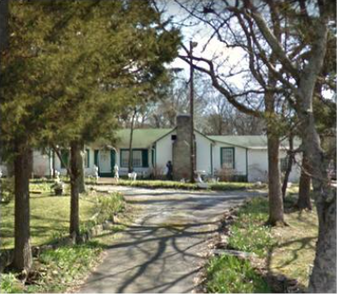 In 1904, missionaries from the Seventh Day Adventist Church arrived by boat at Larkin’s Spring and purchased 412 acres from W.B. Ferguson. They perceived Madison as “the wilderness.” The objectives of the Madison College were to establish a training school for evangelists and missionaries who would devote “their lives to the service of God and betterment of humanity.” By 1908, eight cottages housed 36 students.
As part of the Adventist’s mission, the 12-room Madison Rural Sanitarium and Hospital was established with a revolutionary approach that offered patients “proper diet, fresh air, exercise, hydrotherapy, and a lot of kindness.”
Noted author (“Seven Times Seven”) and leader of the women’s suffrage movement Maria Thompson Daviess came to Madison for successful treatment at the Sanitarium and lived at Sweetbriar Farm (off Neely’s Bend Road), where she entertained “weekend assemblies of editors and illustrators (who) came down from New York and we all lived riotously.”
The church’s operations continued to grow and in 1931, the school acquired Madison Health Foods. Over the next several decades, the college’s reputation grew as it accepted applications from Africa, the Far East and South America and was granted four-year status by the State. An article about the college and sanitarium in Readers Digest helped the school attract 5,000 applications. With the addition of surgery and obstetrics in 1938, the medical facility became known as the Madison Sanitarium-Hospital. A leading Viennese doctor escaping Nazi persecution came to help direct the hospital’s operations. The campus’s fragrant gardens attracted tourists and visitors from throughout the region.
By 1954, the campus had expanded to a 220-bed facility. It continued to grow as part of the Tennessee Christian Medical Center. Eventually, however, both Madison College and the Sanitarium ran into financial difficulties and operations were severely reduced. However, the campus and other contributions of the Seventh Day Adventist Church remained embedded in Madison’s long- term legacy and the church’s regional headquarters remain in Madison today.
Suburban Development
The 1920s saw a brief era of real estate speculation that ended abruptly with the Great Crash of ‘29. The 48-lot Montague subdivision (bounded by Gallatin Pike, Gibson Creek, the river, and Belle Camp Highway (East Due West Avenue) was platted in 1919 and named for Montague Ross. Wealthy visitors used the 17 summer resort homes located along the river as the neighborhood expanded throughout the 1920s to include over 100 lots. The Madison Civic Club was formed to promote Madison in the early 1920s. The 188-lot Madison Park subdivision (Gallatin Road at Neely’s Bend) was advertised as a way to “invest in Nashville’s growth…and to grow with Nashville”. “Fast-growing” Madison itself was advertised to homebuilders as having many advantages including schools, churches, railway, train, and bus service.” The Douglas & Levine subdivision began sales in 1924. Madison Commerce Center was surveyed in 1926. The county’s first school bus may have run in Madison when the County paid Will Goodrich to transport children along Due West Avenue to Old Center School on Dickerson Pike.
Newman Cheek (of the Maxwell House Cheek family) invested heavily in Madison’s growth, first with the development of his own estate “Sherwood Forest.” A WPA travel guide described it as “a private estate in which modern, rough-hewn limestone architecture reminiscent of the Victorian Gothic revival in England, is the dominant feature among grounds and gardens beautifully landscaped.” To supply water, Cheek built a lake that inadvertently covered the remains of Haysborough village. In order to provide a reliable water source for Madison’s development, the Madison Water Company was formed in 1927, soon to be replaced by the Lakewood Water Company. The Civic Club advertised Madison as “Nashville’s Premier Suburban Community.” By the 1930’s, “…much traffic passed through Madison at a high rate of speed, endangering the lives and property of pedestrians,” so the area’s first traffic light was installed.
Nawakwa Hills, Pawnee Trail and Forest Park subdivisions were surveyed and recorded, just as the Depression began, with elites looking for safe investments. The old Crittenden estate was proposed for subdivision and development of 206 lots (on Cherry, Oak, and associated streets). By the mid- 1930s, at least 3,000 people lived in Madison and 10,000 people lived in the combined suburban areas of Inglewood, Madison, Montague, Goodlettsville, and surrounding communities, and there was a fear that growth could be stunted if the water supply were to be cut off trough a failure at the source (Newman Creek). Further, only Goodlettsville had any fire protection. In 1937, Cheek persuaded the General Assembly to permit the incorporation of a public utility (Madison Suburban Utility District) that could purchase the Lakewood water utility and issue bonds without any other municipal government functions. With the start of WWII, suburban housing development came to a standstill in part due to the shortage of materials and manpower. Many of Madison’s finest enlisted in the war effort; plus nearly 40 joined the local Tennessee State (Home) Guard and another 30 became air raid wardens.
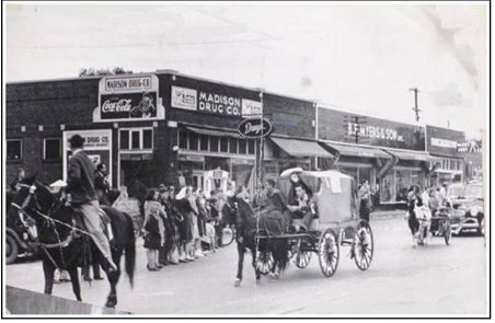 Pent-up demand allowed Madison, now a community of 7,000 people, to generate a post-war building boom starting in 1946. Developer J.R. Coarsey boasted “We believe in Madison – the finest and fastest-growing town in Tennessee.” Although their fear proved unfounded (at least for a decade), some Madisonians attempted to pre-empt any effort from Nashville to annex the community by seeking to incorporate. Coarsey, which developed the 45-lot Rainbow Terrace subdivision, noted that he expected Madison to triple in population within 10 years. Anderson Estates was subdivided by the Madison
Real Estate Company north of Old Hickory Boulevard at the bridge in 1946. Coggin advertised home sites along Neely’s Bend Road to returning soldiers who could now afford to purchase homes through the G.I. Bill.
By the 1950s, Madison’s residential development could support 15 churches and 3 elementary schools (Neely’s Bend, Amqui, and Stratton (named after local education proponent John Taylor Stratton) plus Madison High School. “Hill Billy Day” was established as an annual festival and fundraiser for Stratton School. In its second year, the festival was already drawing crowds estimated at 50,000. Prior to the development of Madison High, local students attended Litton, DuPont, and Goodlettsville high schools. In 1947, Stratton was recognized for excellence by the Tennessee SesquiCentennial Committee through its distinguished Cordell Hull Award.
New development in the 1950s included Archwood Acres, Marlin Meadows, and others. However, a resolution to the sewerage issue became paramount to support continued growth. A public referendum was held in 1955 on the question of incorporation and solutions to the sewerage issue. At that time, Madison had a population of 11,200 and 175 businesses. The initiative failed due to concerns over the legalization of liquor stores and bars.
Music Heritage
Perhaps one of the earliest musicians to put Madison on the map was Joseph MacPherson, the first person to sing on radio station WSM, during the station’s 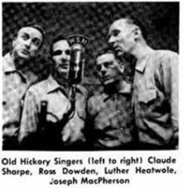 initial broadcast in 1925. Raised at the “old Ellis Place” in Madison and trained by teachers at Ward-Belmont, he went on to perform in Aida as a company member of the Metropolitan Opera in New York and also performed as a member of the Grand Ole Opry in Nashville.
Nashville’s emerging prominence as a recording center and home to the “Nashville Sound” coincided with Madison’s residential boom in the 1950s and 1960s. As such, Madison attracted a number of recording artists to live and work in the suburb’s bright neighborhoods and attractive Mid-Century Modern homes.
Home of Maybelle Carter
Among the artists who established their residence in Madison during this era were Maybelle Carter, Kitty Wells & Johnny Wright, Eddy Arnold, Earl Scruggs, Everly Brothers, Charlie Louvin, Charlie Rich, Jon Hartford, Hank Snow, Loretta Lynn, Patsy Cline, Lester Flatts, Bashful Brothers, and others. A portion of East Old Hickory Boulevard has been renamed to honor Kitty Wells, the “Queen of Country Music.”
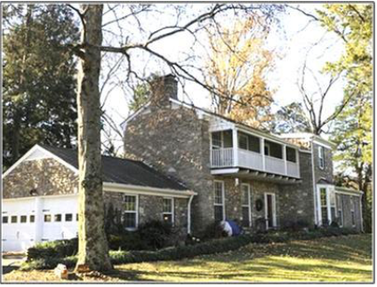 Elvis manager Colonel Tom Parker lived in a stone house on Gallatin Pike that also provided a recording studio and home-away-from-home for The King when Elvis came to Nashville. Virtuoso guitarist Wayne Moss has operated Cinderella Sound Studios out of his Madison garage for decades, producing such artists as Linda Ronstadt, Steve Miller Band, Kiss, Tony Joe White, Chet Atkins, The Whites, Billy Swan, and Memphis Slim, among others. Hank Snow’s Rainbow Ranch served as a recording studio and is now listed on the National Register of Historic Places. Such luminaries as James Brown, Dottie West and Jim Reeves recorded at Starday-King Sound Studios, located on Dickerson Pike.
 Madison continues to host musicians, home recording studios, and popular live music venues like Larry’s Grand Ole Garage, Lonnie’s Bluegrass Festival, and Dee’s Country Cocktail Lounge.
Economic Overview
While part of Metro Nashville, Madison has long had a strong economic identity of its own. As noted previously, Madison has served as the headquarters and manufacturing hub for companies like Odom’s (meatpacking) and W.F. Gray (remedies). Du Pont operated the world’s largest powder plant and later, major chemicals manufacturing facility, just across the river in Old Hickory. And Dollar General Stores, the nation’s 2nd largest discount general merchandise store chain, is headquartered just north of Madison in Goodlettsville. A number of manufacturing and distribution companies continue to operate in Madison’s Myatt Drive Corridor, and newcomers like Diamond Gussett Jeans and Yazoo Brewing are bringing new manufacturing jobs to Madison. Others are working on adding entrepreneurial space for light manufacturing and small batch producers.
Madison has been home to two hospitals – Memorial and Tennessee Christian (formerly Madison Sanitarium) – and HCA Skyline Medical Center is located on the south-western rim of Madison today. Several colleges, including the planned campus of Nashville State Community College, have called Madison home. Metro Government facilities include a new $40 million, 82,500 square-foot facility at 400 Myatt Drive housing a state-of-the-art crime lab, the Madison Police Precinct, and a 5,800 square-foot community meeting venue. Adjacent to this new facility are the Headquarters for the Metropolitan Transit Authority (MTA). Situated along the region’s longest commercial corridor, Madison has long had a substantial retail/commercial base including major regional shopping nodes at Madison Square and RiverGate Mall. The “Motor Mile” attracted large automotive dealers to the area. But the area has also had a long history supporting small businesses, musicians, tradesmen, and entrepreneurs.
Resident Labor Force
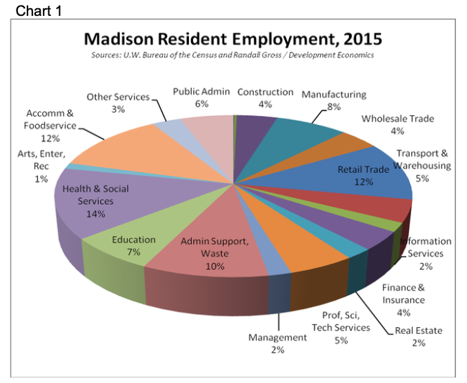
Madison’s residents are employed in a variety of jobs throughout the region. Based on 2015 Census data, a total of 17,600 Madison residents are employed in a diverse set of industries covering all major sectors. The largest share of residents is employed in health & social services (14%), followed by accommodation & foodservice (hospitality, 12%), retail trade (12%), manufacturing (8%), education (7%), and public administration (6%). But Madison’s residents work in a number of other sectors as well. The diversity of the community’s workforce skills is illustrated in the chart below.
Commutation. Today, a significant share of Madison residents works in Madison (e.g., RiverGate), but many more commute to jobs throughout the Nashville Metropolitan Area. Based on U.S. Census data, high concentrations of Madison’s residents commute to work in Midtown (e.g., Vanderbilt Medical Center and other hospitals), Donelson (Opry Mills, Nashville International Airport), East Nashville, Brentwood, and southeast Nashville’s industrial corridor. Since a large number of Madison’s residents work for Metro schools, as contractors, or within the hospitality industry, they commute to a variety of locations throughout Davidson County. A surprisingly small share of Madison’s residents works in Downtown Nashville.
Employment in Madison
There were about 11,400 jobs located in Madison in 2015. The employment base in Madison is heavily oriented to retail trade, which comprises 40% of all jobs in the community. Most of this employment is concentrated in RiverGate Mall and in shopping centers located along the Gallatin Pike corridor. Another 13% of Madison’s jobs are in accommodation and foodservice, mainly in fast food and full-service restaurants. So together, more than half of all jobs in Madison are concentrated in the retail/commercial sector. If Madison were an independent municipality, this dependency on relatively low-wage retail jobs would pose a serious risk to the local economy.
Health and social services account for another 10% of jobs, such as in medical clinics and physicians’ offices, social service agencies and in positions associated with Skyline Medical Center.
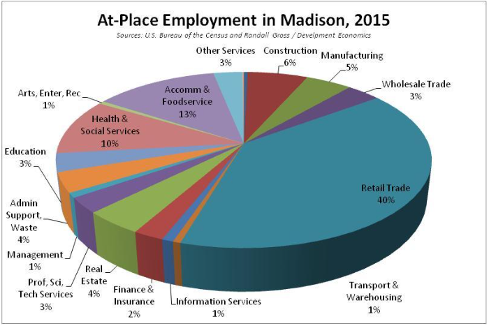
The remaining jobs in Madison are distributed among a variety of other industry sectors. For example, construction accounted for 6% of Madison’s jobs, manufacturing 5%, etc.
Employment Trends. Madison’s employment base has fallen by 5,700 or one-third since 2002. Most of that loss occurred through the national recession by 2010, but the community has continued to lose jobs since the recession ended. The largest job losses were in retail trade (1,740), health & social services (1,060), manufacturing (1,060), and accommodation & foodservice (900). The fastest-declining industries were manufacturing (where Madison lost nearly two-thirds of its manufacturing jobs), administrative support (57%), health & social services (47%), and wholesale trade (44%).
Despite the losses, a few industries have been growing in Madison. The education sector added over 240 jobs and real estate added 140. There has also been a slight turnaround in some sectors that had seen declining employment between 2002 and 2010 but are now experiencing growth. For example, the construction sector lost jobs during the recession but has gained nearly 100 jobs since 2010. The arts, utilities, information services, management services and other services have seen increasing employment since the end of the recession. Overall employment trends are summarized in the following table.
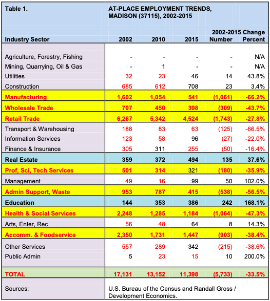
A key issue has been retention of good-paying jobs for residents of Madison and nearby communities, as employment has fallen in manufacturing and other sectors.
Baseline Demographics
A demographic analysis was conducted of Madison in 2016 (based on 2014 data) as part of the initial baseline work for this Strategic Plan. This data was recently updated for the U.S. Census Tracts that comprise Madison.
Population and Households
Based on these Census estimates, Madison has a total population of nearly 42,000, up by more than 3,600 or 9.4% since 2010. Madison represents 6.3% of Davidson County’s total population.
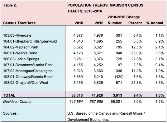
Madison’s population has increased at a rate of 1.6%, slightly faster than Davidson County’s as a whole. This is a remarkable achievement, given that Madison is a relatively built-out section of the county. All of the tracts within Madison experienced an increase in population in recent years with the exception of Tract 108.01, which includes portions northeast of the intersection of Old Hickory Boulevard and Gallatin Pike (south of Rivergate). It is possible that some of the single-family homeowners in this area are aging and becoming empty nesters, with smaller households, or are moving out of the area.
Overall, the nine census tracts in Madison surprisingly retain about the same number of residents, between 4,000 and 6,000, so the population is relatively evenly distributed throughout the community. The fastest population growth has been in the southern Neely’s Bend area (23.0% in just six years) and areas closer into Downtown Madison near Larkin Springs (22.3%). Neely’s Bend also added the largest number of residents, at nearly 1,000 (and areas near Larkin Springs added more than 700). This growth is not surprising, given that these areas are among the more rural and less-developed in Madison. The Graycroft area near Due West Avenue has also experienced fairly rapid growth, with a 21.3% increase in population. The area closer to Downtown Madison added only about 10 residents per year since 2010.
Age Cohorts. Madison’s population was also examined by age cohort, as an important indicator of both market demand and need for housing and various services. Madison’s population is fairly evenly spread among all 5-year age cohorts, up to the age of 70. Each of these age cohorts generally has between 5 and 7% of Madison’s population. So, there is no one age group that dominates the community. The only age cohort for which there is somewhat more represented than others is the 30 to 34 age group (part of the so-called “Millennial” generation), in which about 9.0% of Madison residents reside. Madison’s population-by-age spread was compared with that of Metro Nashville as a whole in the following chart.
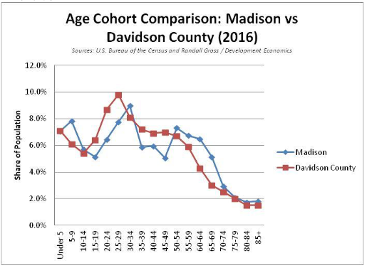
As shown above, Madison tends to have a smaller share of its population in the 15-29 and 35-49 age cohorts, but has a larger share aged 50 and above. A comparison of key life stage age cohorts is shown below.
| Life Stage | Madison | Davidson County |
|---|---|---|
| Children (0-19) | 25.7% | 25.0% |
| Young Adults (20-39) | 29.0% | 33.8% |
| Mid Age (40-69) | 36.7% | 33.8% |
| Senior (70+) | 8.6% | 7.5% |
Young adults represent a smaller share of Madison’s population than in the rest of the county, while Madison has a higher share of both mid-age and senior populations. This finding is not surprising, given that Madison provides a more suburban, “settled” location with a large number of single-family homes. As the Millennial generation ages into families with children, they are becoming more likely to settle in communities like Madison that offer affordable single- family housing options proximate to employment.
Among the various neighborhoods in Madison, Children are more highly represented in Madison Park, Larkin Springs, and Gateway/Ronnie Road. Young Adults are found as a higher share in Rivergate, Downtown/Lanier Park, and Madison Park. Mid-age populations are found in higher shares in Neely’s Bend, Graycroft/Due West, and Rivergate. Finally, seniors represent a higher than average share of the population in Montague/Chippington and Graycroft/Due West (where nearly one in five is over the age of 70).
Race and Ethnicity. A slight majority (52.3%) of Madison’s population identifies as white. In general, Madison is somewhat more racially and ethnically diverse than the rest of Davidson County as a whole.
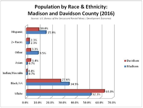
About 34.5% of Madison’s population is black or African-American, versus 27.6% countywide. Madison also has a slightly larger share who identify as American Indian or Hawaiian, but a much smaller share who identify as Asian (0.7% versus 3.4% countywide). A much higher share of Madison’s residents identify with races other than those posed by the Census Bureau’s list.
Madison also has a larger share of residents who identify as Hispanic or Latino, at nearly 16.0% in 2016, up from 12.0% in 2010. This compares with a growing but still smaller share countywide of 10.0% (up from 9.0% in 2010). Those who identify as Hispanic or Latino as an ethnicity can identify with any race, so they are also included in the race categories.
Madison’s Hispanic population is fairly well concentrated in certain areas, including Downtown/Lanier Park (where Hispanics represent nearly 26% of the population), Madison Park (24%), Montague/Chippington (24%), and Shepherd Hills/Edenwold (22%). By contrast, only about 2% of the Rivergate area and 5% of the Graycroft/Due West area population identifies as Hispanic.
Foreign-Born. Madison has an estimated 4,100 foreign-born residents, which represents about 5.0% of Davidson County’s total. Of this number, 85% (3,430+) are estimated to originate from Latin America. Another 370 (9%) are from Asia, and the rest from Africa (160), Europe (60), and North America (30). This population contributes to and strengthens the cultural diversity of Madison and helps to create a workforce available for the community’s growth.
Distressingly, roughly 85% or 3,470 of Madison’s immigrants have not been naturalized as U.S. citizens. While many reside legally as U.S. residents, all are subject to uncertainties regarding their status within the current political climate. Having more than 8.2% of the community’s population living with such uncertainty can impact negatively on the community’s schools, business base, and housing market.
Education
On average, educational attainment among adults 25 and older is lower in Madison than in Nashville as a whole. For example, Census estimates suggest that 14.4% of Nashvillians have attained a graduate or professional degree, but only 6.1% of Madison residents have done so. Almost 24% of adult residents countywide have attained a bachelor’s degree, but only 11% of Madison’s adults have attained a BA or BS degree. By the same token, nearly 19% of Madison adults have less than a high school education, while less than 13% of adults countywide have not graduated from high school (or achieved its equivalent). Most adults in Madison have achieved either a high school degree (33.5%) or have attended some college or received an associates’ degree (30.8%). The following chart illustrates this comparison.
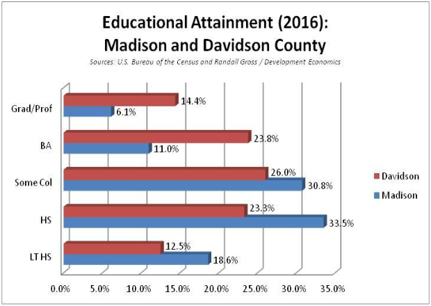
 Educational achievement is not uniform throughout Madison. For example, more than 30% of adults in the Graycroft / Due West Avenue area of southwest Madison have received either a BA or graduate degree. Only 5.7% of Madison Park area adults have achieved these degrees. Meanwhile, more than 30% of adult residents in the Shepherd Hills/Edenwold area of northeast Madison have less than a high school education.
Income & Poverty
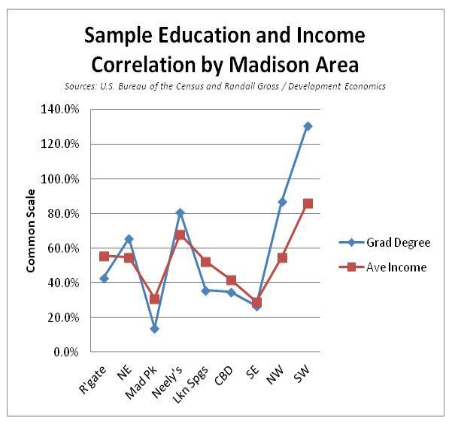
There is often a correlation between education levels and incomes (as illustrated in the sample comparing average household incomes with the share having graduate degrees, at right).
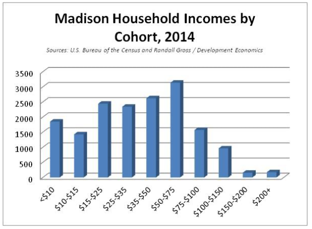
Madison incomes, like its education levels, trail behind countywide averages. The community’s estimated median income (2016) was $38,276, or just 75.8% of the countywide median of $50,484. And Madison’s average household income of $48,269 was only 66.5% of the countywide average of $72,553. Households by income cohort are shown below (using 2014 data).
Madison has a somewhat higher poverty level, at 20.4%, than Davidson County as a whole (17.7%), according to the 2016 Census estimates. Within Madison, poverty tends to be concentrated in certain areas. For example, fully 38.4% or nearly four out of ten Madison Park residents live below the federal poverty level. About 29.0% of the residents in southeast Madison (which includes Chippington Towers) live below the poverty line. And, 24% of residents in Downtown Madison and Lanier Park live in poverty. By comparison, only 7.1% of Neely’s Bend residents live below poverty levels as shown below.
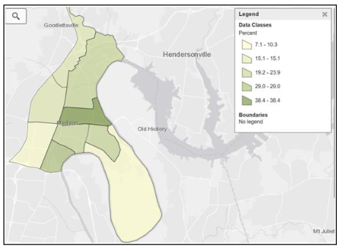
Here it is apparent that Madison has a cluster of households earning incomes within the lower and lower-middle ranges ($15,000 to $75,000), which would be expected for households led by someone who has achieved a high school degree. There is also a number of households with incomes of less than $15,000, which constitutes the householders living below poverty levels. But there are relatively few Madison households with incomes above $75,000, and fewer still earning more than $150,000 per year. Again, education certainly impacts on Madison’s income levels, along with other factors such as the age of householders.
Site Analysis
A site analysis was conducted to examine the existing location, physical characteristics, assets and other features of Madison that impact on its overall marketability and on opportunities for celebrating its unique identity and community. Some key findings from the site analysis are summarized below, with more detail on existing retail, residential, office, and industrial uses provided within the findings from the respective market analyses in the Part B Report.
Cultural and Historical Assets
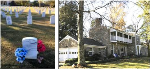 Madison has a large number of cultural and historical assets. Among the historic assets are the restored Amqui Railroad Station and National Cemetery, as well as various sites associated with Madison’s music and religious heritage.
Music-related sites in Madison include the former homes of Maybelle Carter, Kitty Wells & Johnny Wright, Eddy Arnold, Earl Scruggs, the Everly Brothers, Charlie Louvin, Charlie Rich, Jon Hartford, Hank Snow, and others involved in developing the “Nashville Sound.” Other key music-related sites have unfortunately been demolished, such as the home of Colonel Tom Parker (Elvis’s manager). Wayne Moss’s Cinderella Sound Studios is still operating in Madison as is Larry’s Grand Ole Garage Bluegrass Music Park, joined more recently by Dee’s Country Cocktail Lounge. Working musicians throughout Madison continue to maintain studios in the area.
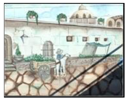
Wall mural in Madison illustrating a village scene in Latin America. Madison has relatively few of these murals or other celebrations of the community’s cultural diversity. But Madison offers many potential opportunities for cultural expression, given its increasingly diverse population and immigrant base, educational institutions including an art college (see below), churches, and other assets.
Educational and Institutional Assets
The new Madison Branch Public Library, Madison Police Precinct Headquarters, a Regional Community Center, MTA Headquarters, and the recently-opened Madison Community Center illustrate government assets located in Madison.
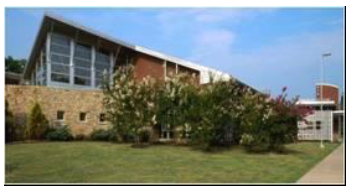 Educational institutions are also important assets for the community, including public and charter elementary, middle and high schools. More detailed information on area schools is provided later in this section. Several colleges in Madison can serve as anchors for revitalization and investment. Among the colleges are Nossi College of Art, Middle Tennessee School of Anesthesia (part of the Madison Adventist Campus), Nashville College of Medical Careers, and the planned new Nashville State Community College.
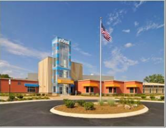
Madison’s churches play an important role not only in the spiritual health of the community but also as service providers and through outreach to those that need help in the community.
The community also has several organizations (Memorial Foundation, Chamber of Commerce, All Together Madison, Discover Madison, etc) as noted previously in this report that help
anchor the community and provide a mechanism for implementation of this plan. The community’s diverse population and business base – the people of Madison – provide the basis for defining Madison’s unique identity.
Anchors & Nodes
Madison has several key commercial and industrial nodes that define historical development patterns and help anchor future redevelopment opportunities. Among these major nodes are Madison Square, Downtown Madison, RiverGate Mall, and Memorial Hospital (Due West Towers), among others.
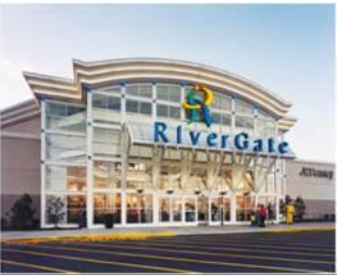
Madison also offers several industrial locations. Areas near I-65, along the CSX rail line, and within the Myatt Drive Corridor provide significant existing industrial uses and development opportunities.
Housing Stock
Madison has a broad diversity of housing stock, including suburban single-family homes, cottages, townhouses, senior living communities, rental apartment complexes, and high-rise apartment towers. In general, smaller cottages, bungalows, apartment complexes, and high rises are located on the east side of Gallatin Pike near Downtown Madison. Suburban ranch-style homes tend to be located on lager lots in newer subdivisions west of Gallatin Pike, along Neely’s Bend Road, or near RiverGate. The condition of the housing stock also varies significantly, as discussed later in this section. Madison’s housing is relatively affordable, but rents and housing prices are escalating rapidly, increasing the risk of “gentrification” and displacement, especially of modest-income renters. More information about the community’s housing stock and market conditions is provided in the Housing Market Analysis.
Architectural Heritage & Vernacular
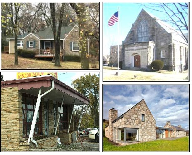
There are several characteristics that help distinguish Madison and establish its unique local architectural vernacular. One of these characteristics is the use of stone in both housing and commercial construction. Whereas large swaths of Nashville are characterized by red brick or wood frame structures, Madison also has a substantial number of stone houses and commercial buildings that distinguish it from other parts of the city. Examples of these stone structures are shown below.
Examples of “Madison Stone” structures:
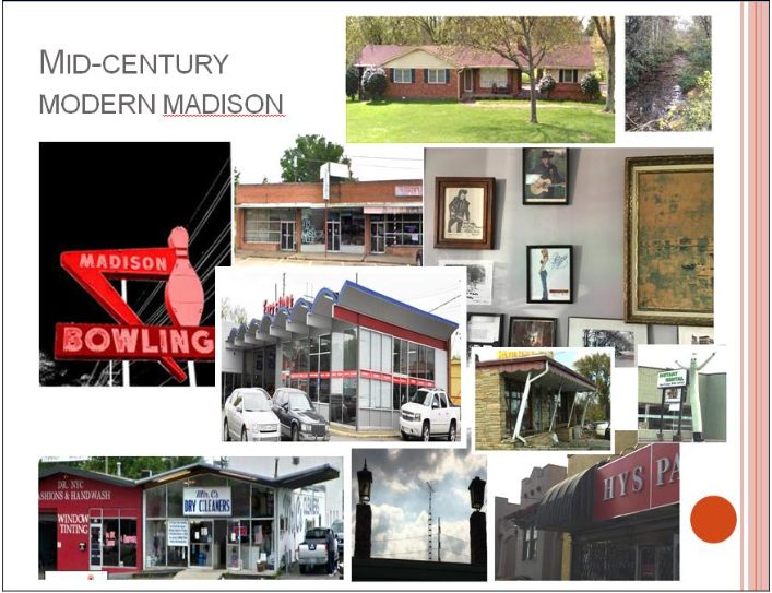
Due to its rapid development during the 1950s and 1960s, Madison also has a substantial number of Mid-Century Modern buildings including both houses and commercial / institutional buildings. Some of the Mid-Century Modern houses were built for music industry celebrities, since the birth of the “Nashville Sound” coincided with Madison’s development as an attractive suburb that attracted new wealth in the 1950s. Iconic Madison entities including Madison Square Shopping Center and Madison Bowl provide commercial linkages to this mid 20th-century heritage.
Mid-Century Modern architecture is not just a distinguishing characteristic but also a design standard that is increasingly popular with young couples and families looking for high-quality design for single-family homes. While other parts of Nashville, like West Meade / Hillwood, Green Hills, Donelson, and other areas have Mid-Century era homes, many are priced above the range affordable to young families or are otherwise being demolished for newer and larger-built homes. Some people are moving to Madison in order to actually restore the original Mid-Century style of these homes. Finally, the vernacular helps to define Madison’s unique identity and brand.
Natural Heritage, Parks, and Recreation Amenities
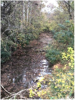 Madison is situated along a long stretch of the Cumberland River and thus, offers both natural and recreational amenities associated with the water. Houses perched along the bluffs overlooking the river in neighborhoods like Montague offer excellent amenity value, with views of the river and the opposite banks. 650-acre E.N. Peeler Park offers a boat ramp with direct access to the river (along with equestrian trails, greenway, R/C model airplane airfield, and other amenities) for recreational purposes. Dry Creek remains a relatively untapped resource as both a natural and recreational amenity.
In addition to Peeler Park, Madison offers the resources of huge Cedar Hill Park (with tennis courts, picnic pavilions, disc golf course, playgrounds) and the recently-opened Madison Community Center at Madison Park. Not far from Madison is the Gaylord Springs Golf Course, Two Rivers Park & Golf Course, Shelby Bottoms Park and Greenway, and other recreational amenities. (Pictured: Dry Creek, from Gallatin Pike, Madison).
Physical Conditions
While Madison offers amenity value through its riverfront property, parks and recreation facilities, well-manicured neighborhoods, and architectural heritage; the community suffers from a number of issues associated with a decline in physical conditions in its commercial districts. Some of these issues are identified below based on field reconnaissance and in discussions with residents and business owners in the community.
Gallatin Pike & Commercial Nodes.
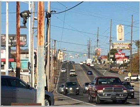 Conditions in Gallatin Pike are characterized by a low-quality physical environment, derived in large measure from a highway orientation that impacts on walk-ability, live-ability and destination market appeal. The streetscape is mangled by a hodge-podge of overhead wires, multiple individual curb cuts, competing and often low-quality business signage, inconsistent street signage and lighting, a lack of tree cover or landscaping and green space, broken or non-existent sidewalks, massive (and usually uninterrupted) paved parking lots, and poorly-constructed building façade treatments. In some cases, there is poor-quality street design and infrastructure, leading to undefined and dangerous pedestrian and vehicular intersections, drainage issues and flooding.
Google’s camera captures a car crossing over the line from Neely’s Bend Road (near Gallatin Pike) into an undefined paved area where people sometimes walk adjacent to City Road Chapel. Due to the lack of curb and gutter, ill-defined roads can cause hazardous conditions for drivers and pedestrians.
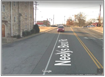
Google’s camera captures a car crossing over the line from Neely’s Bend Road (near Gallatin Pike) into an undefined paved area where people sometimes walk adjacent to City Road Chapel. Due to the lack of curb and gutter, ill-defined roads can cause hazardous conditions for drivers and pedestrians.
On the positive side, Gallatin Pike has recently been re-paved to include bike lanes, which helps create a distinct boundary and safer environment for bicyclists.
Some years ago, the Madison-Rivergate Chamber of Commerce helped sponsor placement of gateway signs at each end of Downtown Madison, and other gateway or welcome signs have been erected in other places (such as along Briarville Road and on Gallatin Pike at the southern entrances to Madison). The signs were a valiant effort at the time to help distinguish Madison or certain sections of it. However, these signs lack consistency and are poorly placed and designed to achieve the desired effect of establishing an area’s unique identity and creating an exciting gateway entrance.
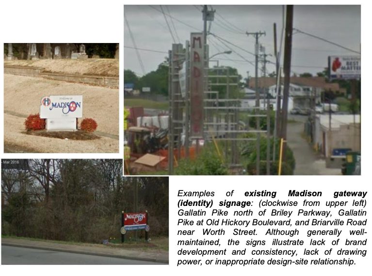
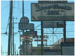 The monolithic commercial business (CS) zoning along the corridor has helped create an uninterrupted commercial coverage, compounded by the absence of programmed green space or landscaping, that is lacking in distinct districts, nodes, or visual “relief.” The zoning and resulting development patterns, augmented by all of the issues associated with physical conditions along Gallatin Pike, contribute to the lack of a strong sense of place at various points along the corridor, or an “identity” for branding and marketing. The streetscape design ignores the community’s heritage.
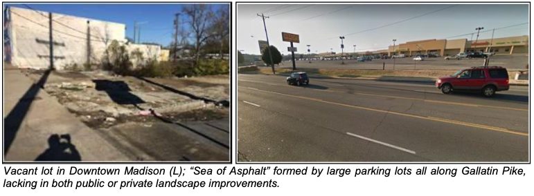
Residential Neighborhoods. Madison has a wide variety of housing built at different periods of time. Housing conditions are generally good, although “spotty” in certain areas. In general, it can be said that newer, suburban neighborhoods located west of Gallatin Pike, along Neely’s Bend Road, or near RiverGate have larger single-family homes in better condition than do some of the older, higher-density neighborhoods on the east side of Downtown Madison. Some of the housing close to Downtown Madison has fallen into disrepair, with a lack of investment and maintenance indicative of and correlated with a high degree of poverty. Some housing was destroyed in the 2010 Flood but Metro Government has purchased and demolished houses in flood-prone areas.
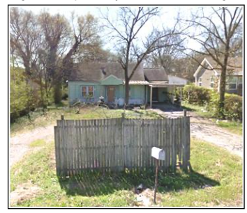
Older house and infrastructure in need of rehabilitation, upgrading, and maintenance.

New Homes and infrastructure in excellent condition.
Similarly, many of the area’s rental apartment communities are well- or adequately-maintained, while others need improvements and better maintenance. Several apartment communities, including Riverchase, Lexington Gardens, and Falcon View, have been cited by public authorities or in private reviews as being ill-maintained, unsafe, or in need of substantial renovation.
Myatt Drive Industrial Corridor. As with residential neighborhoods, conditions in Myatt Drive’s industrial areas are generally good but with some issues and constraints. A key issue is the infiltration of low-quality service and commercial uses like auto repair and used car lots on or near Myatt Drive that degrade the general marketability of the corridor for industrial use. Another issue is the lack of available sites for industrial development. While there are several sites available, there is a need for consolidation of commercial sites and enhanced development opportunities through land assembly. The lack of a focused business development strategy for Myatt Drive and Madison’s economic development in general, also reduces exposure and opportunities for development in the corridor.
Land Use, Planning & Zoning
Madison offers a broad mix of land use, development typologies, and real estate products. Since Madison is not an independent municipality, planning and zoning falls under the jurisdiction of the Metropolitan Government of Nashville and Davidson County. There have been several plans prepared by public and private entities that are particularly relevant to Madison’s development. For example, several of these plans provide zoning and land use policies guiding private development. While this Strategic Plan is not meant to provide a physical land use or zoning plan per se, the Strategic Plan does present development concepts and land use input. So, it is important to understand existing land use as well as planning and zoning policies or actions established by these plans.
Existing Land Use
Madison is largely a residential community, with a population of about 42,000 in more than 19,000 housing units. The community offers a wide variety of housing typologies including single-family homes (cottages, bungalows, ranches, etc), duplexes, attached townhouses, multi-family apartment complexes, high-rise senior apartment buildings, farm houses, group homes, and graduated-care facilities, among others.
Much of Madison’s suburban housing (e.g., ranches on 1/3- and 1⁄2-acre lots) is located on the west side of Gallatin Pike (or southeast in Montague and northeast near RiverGate). High-density housing including senior high rises is located within or near the Gallatin Pike Corridor. Older bungalows and small cottages on 1⁄4-acre or smaller lots are generally located on the east side of Gallatin Pike in neighborhoods surrounding downtown Madison or just north. Finally, low-density rural areas are located south along Neely’s Bend Road. Residential uses comprise approximately 48% of land use in the study area.
There is also a significant concentration of commercial activity, with retail and office uses accounting for an estimated 23% of land use in Madison. Much of this commercial use is concentrated in the Gallatin Pike Corridor and at RiverGate. There is also small office node on Due West Avenue near the former Memorial Hospital site (now Due West Towers).
Farms, parks, and open space account for about 22% of land in Madison. Much of southern Neely’s Bend is taken up by farms and Peeler Park. National and Spring Hill Cemeteries comprise a significant amount of land in south Madison. Aside from Peeler Park, however, there is not much public open space near the Gallatin Pike Corridor or Downtown Madison (other than relatively small Madison and Lanier parks. Cedar Hill Park is substantial, but is located on the west side of I-65 closer to Dickerson Pike.
Finally, the remaining 6% of Madison’s land (aside from roads, waterways, and infrastructure) is in industrial use. And, much of that use is concentrated along the Myatt Drive Corridor, although there is also some older, “second-tier” industrial service use scattered along the rail line, west of Gallatin Pike.
Building Use
A detailed building use analysis was conducted in 2017 specifically for the Gallatin Pike – RiverGate Corridor and several other key nodes. A building-by- building inventory was established based on field reconnaissance, interviews, and assessment records. Based on this data, it was determined that Gallatin Pike has a total of nearly 8.0 million square feet of building space within Madison.
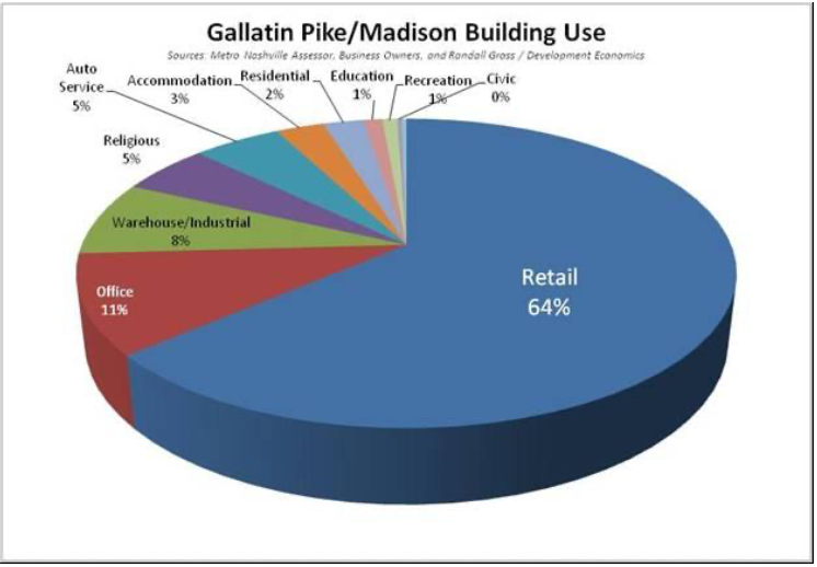
Nearly two-thirds of all building space in Gallatin Pike is utilized for retail / commercial purposes. Thus, retail uses overwhelm all other land and building use within this long, four-mile corridor through Madison. Office uses account for about 11% of the space, while warehousing and storage (including many self- storage units) takes up 8%. The next most significant uses are auto service and religious institutions (mainly churches) each accounting for about 5% of building use in Gallatin Pike. Lodging, mainly concentrated near RiverGate Mall, accounts for about 3% of the space. Housing only accounts for 2% of building space in Gallatin Pike, suggesting that there is very little mixed-use or residential development to break up the commercial strip character of this long corridor.
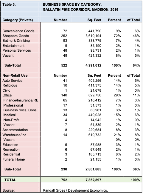
As shown above, the Gallatin Pike Corridor (and surrounding commercial areas) has a total of nearly 7.9 million square feet of building space, with about 5.0 million square feet in retail alone. There is more than one million square feet combined in automotive service and storage facilities in Gallatin Pike and it can be argued that these uses, while certainly necessary, may not represent the highest and best uses at certain key locations. Only about 88,000 square feet was in education use (when the inventory was conducted in 2017), but the new Nashville State Community College campus will add significantly to this number (replacing vacant commercial space). Other changes are now underway that will shift the land use dynamics in Gallatin Pike, with vacant space like the Madison Bowl building and others soon to be rehabilitated for new uses. Other buildings, like the 445,000 square foot Kmart shopping center have since been vacated but are likely to take on new uses in the near future.
The Myatt Drive Industrial Corridor was also inventoried and it was established that the corridor has a total of about 2.9 million square feet of building space. Of this, about 85% is in industrial uses (warehouse/distribution, manufacturing, etc) but significant space is also in retail/commercial, waste disposal, lodging and other uses not directly associated with the industrial base in the corridor.
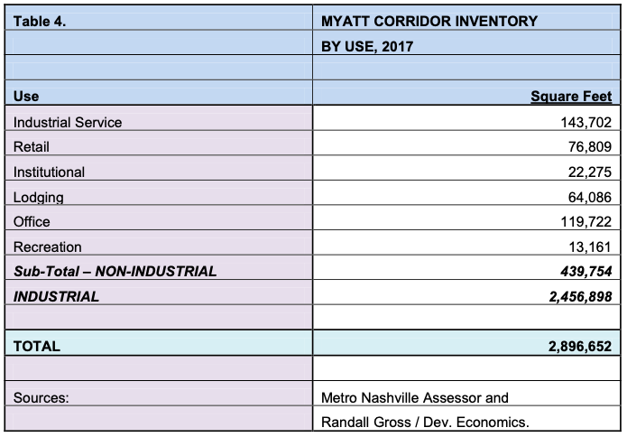
Finally, the Due West Avenue Office Node has about 950,000 square feet of building space, including the 560,000 square-foot Due West Towers campus of former Memorial Hospital. Due West Towers is largely vacant, although portions are being leased to Metro agencies, religious institutions and small uses. Remaining office space in this node is primarily occupied by medical clinics and health care providers who originally clustered there for proximity to Memorial Hospital. There is also some ancillary retail/commercial use, as well as the massive Goodpasture Christian School, located in this node.
Nashville Next, A General Plan for Nashville & Davidson County (2015)
Nashville Next is the comprehensive plan prepared by Metro Planning with a statement of vision, goals, planning policies, and actions to guide development of the city. The plan provides context for development based on overall planning principles and on the community’s vision for development within their own neighborhoods and citywide. The plan focused on key issues, including neighborhood preservation, transit accessibility, natural resource conservation, walkability, and affordability. In general, an action is required by private or public entities in order to enable or trigger the realization of each of the specific components of the plan.
Volume III: Community Plan for Madison. The Community Plan for Madison (MCP) provides more specific attention to policies and actions relating to the Madison Community, as part of the overall Nashville Next Plan. The plan’s definition of “Madison” includes Goodlettsville but excludes areas around Cedar Hill Park. Key elements of the community plan are discussed below.
- Transects. As a guiding principle, transects help define the character of development that is envisioned in each area of the city, and thus underpins more specific policies and development approval decisions. Often, the transects simply categorize or describe the character of development that already exists. Within Madison, the following transects or character areas are designated:
- T1 Natural – E.N. Peeler Park
- T2 Rural – Lower Half of Neely’s Bend
- T3 Suburban – Various Residential Neighborhoods
- T4 Urban – Downtown Madison and Surrounding Neighborhoods, (especially on the east side of Gallatin Pike)
- T5 Centers – RiverGate Mall and adjacent Commercial Areas o T7 District – Myatt Drive (Special District)
The MCP also defines Gallatin Pike to Old Hickory Boulevard as a “Priority Corridor” with “Immediate Need.” Gallatin Pike north of Old Hickory and Old Hickory Boulevard itself are Priority Corridors with “Long-Term Need.”
- Growth and Preservation (“Vision”) Concept Map. This map illustrates the “vision” for the Madison community, which built on Metro’s 2009 Madison Community Plan update and integrated new growth and community stakeholder input.
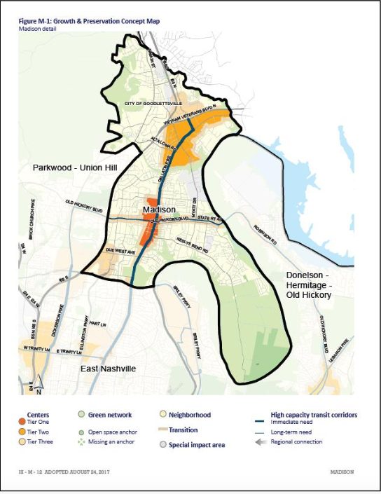
The Concept Map identifies centers, open space and green networks, special impact areas, and transition zones. It also identifies high-capacity transit corridors.
Centers. Centers are intended as active, mixed-use, and “pedestrian- friendly” places with frequent transit service. The Downtown Madison area is designated as a “Tier One” Center. Tier One Centers are meant as the “focus of coordinated investments to shape growth and support transit service in the next ten years.” This designation extends along Gallatin Pike from Madison Square (the southern branch of Gibson Creek) north to Old Hickory Boulevard (on the east) and further north to Nesbitt Lane (on the west). The center also extends 1-2 blocks east or west of the Gallatin Pike corridor.
The RiverGate Mall area is designated as a “Tier Two” Center, which would “receive some investments to manage growth.” Also near RiverGate is the Conference Drive area, designated as a “Tier Three” Center, with no pro-active public investment other than to support “current functions.” (While no public investment was targeted in the plan, there is significant private investment with new lodging and senior facilities). Another Tier Three Center is located at Due West Avenue and Ellington Parkway.
Green Network. The Green Network includes much of the southern half of Neely’s Bend, plus creeks and other wetlands, cemeteries, and Madison Park. Cemeteries aside, the only designated and defined public open spaces are Madison Park and Peeler Park (plus Cedar Hill Park, which is not included in the Madison Community Plan). These represent a relatively small number and distribution of open spaces for a population exceeding 40,000 people.
Impact Area. The Myatt Drive Corridor is considered as a “Special Impact Area,” and does have Supplemental Policy (SP) in place which requires a higher level of design review for development approvals.
- Community Character Policies Map. Another key component of the Community Plan for Madison is the Community Character Policy, which delineates and aligns the transects with more specific definitions for guiding community character. This map seems to have several anomalies, such as the lack of distinction in character for the Memorial Hospital Site, which is shown as having “Suburban Neighborhood Maintenance” as a transect designation rather than any desired urban commercial or mixed- use component.
Meanwhile, the Tier One district designated for downtown is shown as having a mix of T4-MU urban mixed use, T4-NC urban neighborhood center, T4-CM urban mixed-use corridor, civic, T4-CC urban community center, and T4-NW urban neighborhood maintenance; with a “Supplemental Policy Area” designated specifically for the historic downtown core (with design, parking, market, and building reuse considerations that orient the district towards a pedestrian-friendly destination “Main Street.” This mix of character designations can yield a confusing portrait of what exactly Metro envisions as the character of this area. Yet, overall, there appears to be the intent to encourage a mixed- use, urban, transit and pedestrian-friendly environment expressed through various patterns of development.
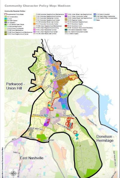
Other Supplemental Policy (SP) areas include Myatt Drive (as noted above); Upper Neely’s Bend (Infill at former Odom’s Sausage plant, encouraging more diverse housing opportunities); the “Motor Mile,” (south of RiverGate, encouraging auto-related use); and Larkin Springs (“Neighborhood Evolving”, to ensure an active street front).
Nashville Next also references the Nashville Open Space Plan, Plan to Play: Countywide Parks and Greenways Master Plan, Access Nashville 2040 and other previous plans.
nMotion Plan (2016) and Let’s Move Nashville: Metro’s Transportation Solution, TIP (2017)
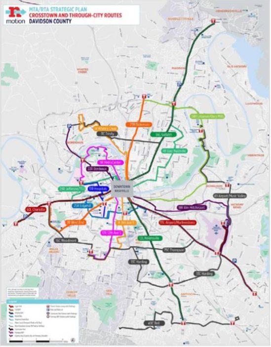 Several plans have recently been developed in response to the need for long-range transportation planning in the greater Nashville region. nMotion was created in 2016 by Metro, MTA, and RTA as a “comprehensive approach to meet the region’s long-range vision for transit. Informed by nMotion, a specific County called Nashville” created through local leaders in anticipation of a public referendum to be held in May 2018 to fund major transit initiatives. Let’s Move Nashville was informed by nMotion and provides a Transit Improvement Program (TIP) describing “the mobility, societal and economic benefits” of a proposed transit program.
The TIP proposes elements including a frequent transit bus network, access and mobility on demand services, light rail transit, neighborhood transit centers, new cross-town bus routes, new rapid bus service, a downtown transit tunnel, and integrated commuter rail (some of which already exists).
Gallatin Pike is identified in both nMotion and the TIP as a high capacity corridor with potential for light rail. Gallatin Pike has been highlighted as a priority, and the TIP proposes light rail at least to Briley Parkway (to a proposed transit center and park & ride terminus near National Cemetery) as part of the first phase of funded light rail development. Enhanced rapid bus service is proposed for areas north on Gallatin Pike into Madison and Rivergate. Ultimately, it is envisioned that light rail service would extend north to downtown Madison and beyond.
Madison Commercial Village Plan (1998)
A plan was created for the “Madison Commercial Village” in 1998, as part of the Metro Planning Commission’s “Small Area Planning Process.” The study area, which comprised of the historic business district, was bounded by Old Hickory Boulevard (N), CSX Railway (W), Neely’s Bend Road (S), and Brooks/2nd Avenue (E). There was a steering committee established and several community meetings held with attendance ranging from 12 to 65 individuals. While the plan is now 20 years’ old, several key recommendations from that time are worth noting, including a couple that have since been implemented:
- Organizational
- Establish an “Oversight Committee” to monitor progress and “initiate action on, provide guidance, manage, coordinate, or otherwise foster the achievement of …the plan.” The Chamber of Commerce was designated to take the lead in creating the oversight committee.
- Create a Community Development Corporation (CDC) to facilitate and act as a “catalyst for development,…a community-based entity that functions like a developer to assemble land for resale for builders and/or for development and leasing by the ‘corporation.”
- Plans and Studies
- Create a Master Plan for the Taylor-Stratton Site (which then became the site of the new Madison Branch Library).
- Undertake a Market Analysis for the Village to identify overall growth potential and opportunities, and any “market niche” activities that could be undertaken. It was also recommended that implications of the market analysis be applied to the plan.
- Create a “community-based” landscaping/beautification plan with concepts, guidelines and criteria, and specific improvement proposals for thematic design.
- Undertake a parking needs analysis.
- Undertake a feasibility analysis for extending Woodruff Street to Brawner at Hickory Street and closing portions of Hickory Street for parking.
- Undertake a feasibility analysis for creating a new north-south street system on the east side of Gallatin Road to allow circulation between Neely’s Bend and Old Hickory.
- Undertake a drainage study for east-west water course drainage.
- Programs
- Increase the Police presence and pursue available programs, patrols, and effective techniques. (A new Madison Precinct HQ has since been constructed on Myatt Drive).
- Hold regular “town hall” meetings to communicate about safety. Educate citizens about reporting crimes.
- Institute neighborhood watch program (some of which now operate)
- Create a task force on gangs and graffiti.
- Create task force on serious crime.
- Establish business recruitment program.
- Create start-up business and incubator programs.
- Institute a counseling program to help foster business retention.
- Prepare materials and establish events for marketing.
- Regulatory
- Review existing base district zoning
- Considerestablishingurbandesignandneighborhoodconservation overlay districts.
- Physical Improvements
- Fund a permanent police precinct (which has been accomplished).
- Integrate streetscape improvements as part of intersection improvements at Gallatin Pike and Old Hickory Boulevard.
- Prepare site for new regional library (which has been accomplished).
- Obtain funding for Neely’s Bend Road Extension to Douglas Street (which is being implemented at present, 20 years later).
- Create a greenway buffer along the north fork of Gibson Creek.
- Improve the intersection of Gallatin Road and Neely’s Bend Road (as recommended in the Gallatin Pike Corridor Study).
- Provide public parking at front of the Taylor-Stratton site as part of the plan for the new library.
- Identify a site for a commuter railway station in the southwestern section of the Village, with ultimate use for rail transit, and initial use for park-and-ride.
- Construct improvements to support transit stops along Gallatin Pike as identified in the Gallatin Pike Corridor Study.
- Identify and address sidewalk deficiencies.
- Construct curb, gutter and sidewalk improvements as envisioned in the Concept Streetscape Plan.
- Implement aesthetics/beautification program.
- Private property owners should maintain their property.
An Action Plan for Reinvestment and Revitalization in Madison TN (2012)
The Urban Land Institute (ULI) sponsors Technical Assistance Panels (TAPs) nationwide that focus on development questions in specific areas, usually through a brief but intensive 1-2-day process. A TAP Action Plan was produced for Madison in 2012. While the process did not benefit from a full market analysis or extensive engagement process, it did produce several tangible recommendations including the following, aimed in large measure to “encourage population growth as a means to stem the tide of disinvestment…”
- Madison leadership should focus on population growth (adding more “rooftops”) in part by diversifying the housing mix, to support the commercial activity in the area
- Strengthen Madison’s identity, such as through events that attract people from a broader area.
- Expand leadership to reflect today’s Madison.
- While previous plans have made recommendations for all of the Gallatin Pike corridor, it is best to focus attention on one “demonstration” area.
Madison Square Master Plan (2018)
The owners of Madison Square Shopping Center contracted with Hawkins Partners to prepare a master plan for mixed-use redevelopment of the site and establishment of a UDO to enable those changes. The master plan has been informed by the market analysis and concepts developed through this Strategic Plan. In general, the proposed master plan conforms to the recommendations provided in this Strategic Plan. However, there are a few components that diverge from the recommended concepts, as discussed later in this Strategic Plan.
Infrastructure
Much of Madison was only recently added to Metro Nashville’s Urban Services District (USD), which provides a higher level of urban services than the General Services District (GSD). Nevertheless, as noted elsewhere, most of Madison already had substantial urban infrastructure in place for decades, including existing water, sewer, power, wastewater, lighting, and (although spotty) sidewalks. Madison is unique in Metro in having its own home-grown water utility, the Madison Suburban Utility District, which has provided high- quality water services in Madison since 1939. Residents have noted the presence of the MSUD as a real asset for the community.
Key Issues
While this plan did not include an engineering analysis to assess infrastructure or services, there are some issues that have been identified by the community, some of which are being addressed by Metro Government. Drainage, for example, is a serious issue, particularly in the eastern portions of central-east Madison. Metro has purchased and demolished homes within the flood plain southeast of downtown Madison, leaving several open space areas without a clear definition of use. Removal of homes in the flood plain does help reduce the likelihood of property damage in the future.
The quality of the streetscape has also been identified as a serious issue, particularly in commercial areas along Gallatin Pike. The lack of streetscape treatments and elements including street trees and landscaping, pavers, consistent or controlled business signage, attractive signs and lighting, wayfinding, consistent sidewalks, seating, underground wires, and other elements contribute to the aesthetic problems which in turn impact on Madison’s marketability.
Also a key issue is pedestrian safety along Gallatin Pike but also in other areas of Madison. Part of the issue is the design of the road, with highway metrics that allow for high-speed acceleration, poor sight lines, and sudden congestion points. Downtown Madison, in particular, is not conducive to pedestrian activity because of the challenges in crossing a five-lane highway. Timed traffic signals and the lack of traffic calming mechanisms contribute to the problem. The recent paving of Gallatin Pike, including brightly-painted bike lanes, help improve some of the aesthetics and certainly bicycle safety within the road itself.
It is unclear as to the roll out of high-speed Internet service within Madison, but the availability of high-capacity, high-speed services are becoming more important as a determining factor in business location decisions. So, to remain competitive for business, Madison should have access to the best Internet infrastructure available.
Projects
There are several major capital infrastructure projects proposed or underway that could significantly alter Madison’s future development. First, a new $6.0 million link is being created along Madison and Douglas Streets to Old Hickory Boulevard. This new road, known as “Station Boulevard” would provide better access to various businesses and institutions in this area. The road will also open up new development opportunities linking with the Fifty Forward Senior Center, Madison Square, Downtown Madison, and an associated park, transit station, or other public use.
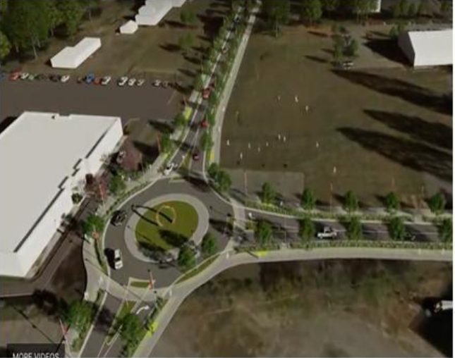
The Mayor’s proposed Transit Plan (TIP) envisioned citywide public transit improvements that would have included the First
Phase addition of Light Rail from Downtown Nashville to just north
of Briley Parkway (at National Cemetery), with a later phase
extending the line to Downtown Madison and beyond. In the first phase, the plan envisioned an upgrading of rapid bus service along Gallatin Pike, north of Briley Parkway. A map of the proposed upgrades and new services is provided below. Funding for the plan was not approved in a public referendum held in May, 2018. Ultimately, a decision to move forward with mass transit on Gallatin Pike, including upgraded bus services, would have a positive impact on Madison’s marketability as a location for housing and business development.
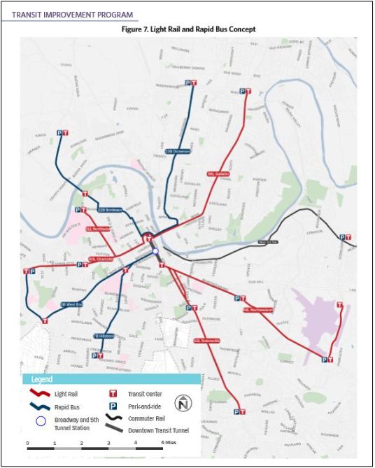
Other capital projects valued at $187,014,102 are also proposed for Madison as part of the adopted FY2017- 2018 Capital Improvements Budget (CIP) for Metro Nashville. Planned Public Works Department projects include sidewalks or other streetscaping along Gallatin Pike in Rivergate, Delaware Avenue, Forest Park Road, and Old Hickory Boulevard. School renovations and/or additions have been planned
for some time, at Stratton, Neely’s Bend Elementary, Amqui, Hunter’s Lane, and Neely’s Bend Middle. Equipment replacement at the Dry Creek Wastewater Treatment Plant is a high priority for Water/Sewer. The County Clerk has planned renovation of their Madison Branch facility while Metro Police has planned expansion of laboratory and other facilities at the Madison Precinct.
Funds have been budgeted (through grant funds) for public arts in the Madison area; and MTA has planned the addition of cross-town bus service in nine corridors, including Briley Parkway through Madison. Finally, Metro Parks has proposed a new nature center to be built at Cedar Hill Park. Most of these projects are not necessarily prioritized or funded for the current fiscal year, with the possible exception of improvements to the Dry Creek Wastewater Treatment Plant. The largest planned project is a $72,290,000 renovation to Hunter’s Lane High School, accounting for nearly 40% of the total CIP funds budgeted for Madison. The smallest proposed project is the $490,000 Metro Arts Commission’s Madison public arts project.
Social Conditions
Madison has a diverse population. Among those who can benefit from social services are seniors, disabled, hard-working families with children, young struggling musicians, recent immigrants and transplants; those with social, health, and mental problems; those seeking employment, those returning from prison or active military duty, and others.
The Madison area offers a variety of social programs to support the community’s needs, led by churches and social service non-profits based in Madison. As noted earlier, poverty is fairly concentrated within a few neighborhoods in Madison, such as in areas east of downtown and many of Madison’s existing social service providers are concentrated in or near the downtown area.
A declining number of affordable housing opportunities in Madison can leverage gentrification, displacement, and related social problems. Metro-wide, housing affordability issues were by far the biggest single need identified by constituents of Metro Social Services. This issue has also been prioritized by Madison residents in public meetings and online conversations. Madison Census Tracts have among the highest proportion of cost-burdened renters and homeowners (paying more than 30% of their income for housing) in Davidson County. In 7 of Madison’s 9 census tracts, 50% or more of renters are cost- burdened. And more than 50% of homeowners in 5 of Madison’s 9 census tracts are cost-burdened. In fact, Madison is among the most cost-burdened communities for both renters and homeowners in Nashville.
Crime and safety are perceived to be issues in Madison, although the community compares favorably in its crime rate with some other neighborhoods in Davidson County. Finally, the community’s schools have a proud history but also a mixed reputation largely due to the high levels of poverty and associated social issues that pervade the school system at large. More detailed assessment is provided below.
Health
Madison has long had the full range of health care services available through its two (now one) hospitals, medical and dental clinics, professional services, and other providers. At present, perhaps the most serious health crisis impacting on Madison is heroin addiction, which is increasing in Nashville and throughout all of Tennessee’s large urban areas. The state’s heroin hospitalizations increased by 641% between 2009 and 2014 (according to the Tennessee Department of Mental Health & Substance Abuse Services).
Parts of Madison are designated as “food deserts” by Metro Social Services (MSS) in their 2016 Community Needs Evaluation. The northeast portion of the community (north of Old Hickory Boulevard and east of Gallatin Pike) is characterized as “low income, limited access to grocery stores and limited access to a vehicle.” SNAP/Food Stamp program beneficiaries are concentrated in portions of Madison, mainly in neighborhoods near the downtown area. Madison does have fairly good park and recreation coverage (within a 1⁄4 to 1⁄2 mile walking distance of residences) to support good health, except for the swath of neighborhoods along the west side of Gallatin Pike (based on Metro Planning Department Data compiled in 2016). Among all key social indicators tracked by the Healthy Communities Institute, Madison scores 4 out of 5 in terms of the Socio Needs Index (with 5 being the most in need). This index is “correlated with preventable hospitalization rates and premature death.”
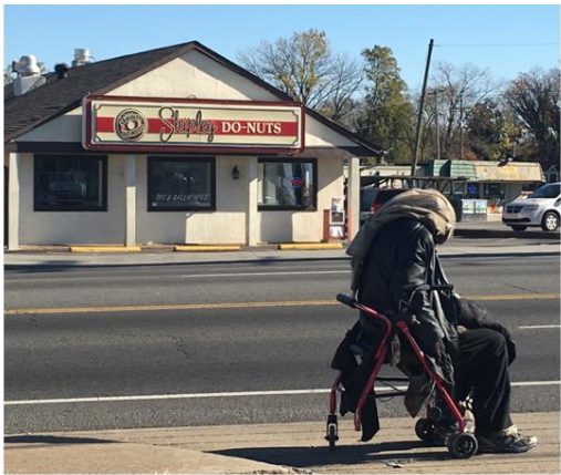 Homelessness
Homelessness has been identified as a serious issue in Madison, with a particular focus in the downtown area. It has been theorized that a homeless population has concentrated in Madison in part because of the availability of rehabilitation and other social services located there. Some also posit that homeless have been “pushed” north into Madison from Downtown Nashville. The small cluster of pawn shops has also
attracted homeless, particularly addicts, whose cycles of dependency increase their
occasional need for easy cash to purchase drugs. The availability of affordable housing in Madison may be declining, which also leads to an increase in people seeking temporary housing assistance and social services.
Crime & Safety
Many residents have noted that safety appears to have improved in Madison since the establishment of the new Metro Police Precinct headquarters on Myatt Drive. The visibility of the police has certainly become more widespread, which may help deter criminal activity. While many residents note that crime does not affect them directly in Madison, some of those who live in other parts of Nashville and the region perceive Madison to have a crime problem, in part because media reports sometimes confuse Madison with the Madison Police Precinct (which includes areas outside of Madison proper where crime is more prevalent). These negative perceptions impact on Madison’s image and marketability.
Total Number of Crimes. The reality is somewhat mixed. Overall, Madison had 3,773 UCR Part 1 (serious) crimes in 2016, accounting for about 11.6% of all serious crime in Metro Nashville. Madison’s council districts are generally ranked somewhere in the top half of Metro’s crime statistics. For Part 1 (serious) crimes, Council District 8 is ranked 9th (out of 35 districts) in terms of its share of Metro Nashville incidents, accounting for 3.6% of Part 1 crimes overall. Property crimes account for the bulk of the incidents and District 8 is ranked 8th in property crime (but 11th in violent crime). District 9 is ranked 13th in Part 1 crimes while District 7 is ranked 18th and District 10 (which includes RiverGate) is ranked 20th. District 3, which straddles the western edge of I-65 is ranked 10 overall.
| Council District | Violent Crime Rank/ % of Metro | Property Rank / % | Total Part 1 Rank / % |
|---|---|---|---|
| District 7 | 15 / 2.9% | 18 / 2.5% | 18 / 2.6% |
| District 8 | 11 / 3.4% | 8 / 3.7% | 9 / 3.6% |
| District 9 | 12 / 3.3% | 17 / 2.6% | 13 / 2.8% |
| District 10 | 25 / 1.4% | 15 / 2.9% | 20 / 2.5% |
Such statistics can be misleading, since areas with a large population or a large number of businesses may naturally have more crimes reported than less- densely populated areas or areas without large concentrations of commercial activity. In Nashville, areas with high concentrations of public and assisted housing also tend to correlate with higher Part 1 crime numbers.
Crime Rates. To better understand Madison’s position with respect to crime, an analysis of crime rates was conducted, looking at Part 1 crime per population and per number of businesses. This analysis determined that Madison’s Part 1 crime rate (per capita) was 0.0956, or exactly twice the rate of Metro Nashville as a whole (0.0477). This seems to suggest that Madison has a more serious issue with crime relative to its population than do other areas of the city.
However, another way of looking at the crime rate is on a per-business basis. Madison is situated along Gallatin Pike, which is the longest commercial corridor in the region and contains nearly 5.0 million square feet of retail space within Madison alone. Crime is often attracted to retail/commercial areas because of the number and availability of targets for theft, burglary, rape and other Part 1 crimes, not to mention petty crimes and traffic infractions.
Crime in commercial areas can also be correlated with health issues when heroin addicts are in desperate need of cash to purchase drugs, leading some to engage in theft and petty crimes. Addiction services provided in Madison have helped attract and assist people especially with heroin addiction, and businesses have noted a distinct uptick in the number of addicts concentrating in the downtown Madison area. Statewide, heroin possession arrests increased from 0.57 per 10,000 people in 2009 to 4.30 per 10,000 by 2016, according to the Tennessee Bureau of Investigation CJIS Support Center, representing a 654% increase in arrests.
Because of Madison’s high concentration of retail/commercial businesses, it would not be surprising to find that the area has a higher-than-average number of crimes, because of the large number of commercial businesses. And, there does seem to be a correlation: Madison actually has more than 20% of Metro Nashville’s retail businesses, based on the inventory conducted for this plan and on the U.S. Census of Retail Trade. Madison has about 12% of Metro Nashville’s Part 1 crime. The fact that Madison has 20% of retail businesses but only 12% of Part 1 crime is expressed as a lower crime rate in Madison: Madison has 7.23 crimes per business, while Metro has 12.6 crimes per business overall. Thus, given Madison’s high concentration of commercial activity, it has a lower crime rate per business than the city as a whole.
| Madison | Metro Nashville | |
|---|---|---|
| Per-Capita Crime Rate | 0.0956 | 0.0477 |
| Share of Metro | 2.0 | |
| Per-Business Crime Rate | 7.2280 | 12.6041 |
| Share of Metro | 0.6 |
While crime is a very complicated social problem to explain, it can be argued that a significant driver for crime activity in Madison is the simple fact that Madison has a large and vibrant business base which, in turn, provides more opportunities (“targets”) for crime. The same could be said for Green Hills and other major commercial nodes in the city. Yet, given the larger business base in Madison, the crime rate is relatively low compared with the city overall.
Education
Madison has a rich history in education, especially as the home of Madison College and subsequent educational and medical institutions established by the Seventh Day Adventist Church. Madison’s public schools formed the backbone of the community during its rapid suburban development in the 1950s and 1960s, and the Madison High School Alumni Association remains an important link to Madison’s past. Today, the community boasts nine public and charter schools (six elementary, two middles, and one high school – located just west of Madison on Dickerson Pike). Madison also has four very active private parochial schools representing Adventist, Catholic, and Church of Christ denominations. Goodpasture Christian School is perhaps the largest of the private institutions, with pre-k to 12th grade enrollment of about 1,000.
Elementary Schools
- Neely’s Bend – 1300 Neely’s Bend Road
- Smithson Craighead (Charter) – 730 Neely’s Bend Road
- Stratton – 310 Old Hickory Boulevard West
- Amqui – 319 Anderson Lane
- Gateway – 1524 Monticello Avenue
- Chadwell – 321 Port Avenue (west of I-65)
Middle Schools
- Madison – 300 Old Hickory Boulevard
- Lead Neely’s Bend Middle/College Prep (Charter) – 1217/1251 N.B. Road
High Schools
- Hunters Lane – Dickerson Pike (west of I-65)
Private/Parochial Schools
- St. Joseph’s Catholic School (K-8) – 1225 Gallatin Pike
- Goodpasture Christian School (PK-12) – 619 W. Due West Avenue
- Madison Academy (9-12) – 100 Academy Road
- Madison Campus Elementary School (1-4) – 1515 Sutherland Drive
Based on the Tennessee Department of Education Report Cards, Madison’s public schools universally rank lower (on average) on nearly every subject score than those for Metro Schools as a whole. Composite ACT scores at Hunter’s Lane High School are also lower (16.5 versus 19.0) than for Metro Schools, although the graduation rate is equal (80.3%). In some subjects, Hunter’s Lane students ranked distressingly low, such as in History (with nearly 60% performing Below Basic level) and English II (40% Below Basic). Only in one area did Hunter’s Lane students appear to perform much better than Metro students as a whole – Chemistry, where only 12.6% of Hunter’s Lane students ranked Below Basic compared with 44.0% of Metro students as a whole (and nearly 15% of Hunter’s Lane students ranked as “Advanced”). Whether the Chemistry score is an anomaly or there is a very good Chemistry program at Hunter’s Lane is not clear.
Obviously, these scores only provide one simplistic measure of a very complex assessment and may not necessarily indicate the quality of education nor the commitment of teachers. Poverty has an enormous impact on such scores, and Madison’s schools all have a higher percentage of “Economically Disadvantaged” pupils than Metro as a whole (50.6%). For example, 55.8% of Hunter’s Lane students are disadvantaged and 71.1% of Madison Middle’s students are disadvantaged. Another factor is language proficiency, with three of Madison’s seven ranked schools having much higher shares of English Learners in their student population than Metro as a whole (18.9%). More than one-third of students at both Neely’s Bend Elementary and Stratton Elementary speak English as a second language.
Coming into the schools with higher rates of poverty, with parents working multiple jobs to pay rapidly-escalating rents, and with less exposure to the English language, students in Madison do not fare as well on tests; but that doesn’t necessarily mean that the quality of their education is any worse than at other schools in Nashville. That being said, aging building conditions, a fear of violence or of other people, and the poor academic reputation of public schools (whether founded or not), continue to send some families to private, parochial and charter schools.
Competitive Advantages
Madison has a number of competitive advantages for attracting residents, businesses, and commercial or industrial development. Several of these advantages are highlighted below.
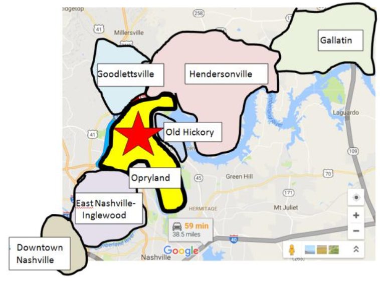 Central Location
The community’s central location just 9.5 miles (18 minutes) north of Downtown Nashville is certainly a key advantage for residents and businesses alike. Being located at the center of the region’s longest (30-mile) commercial corridor is also an important feature.
Excellent Accessibility & Exposure
Direct ingress and egress from Interstate 65, Briley Parkway, and Ellington Parkway provides access to Downtown and points throughout the Nashville Metropolitan Area, especially to the north/east suburbs including Goodlettsville, Hendersonville, Gallatin, Donelson, Hermitage, Mt. Juliet and Lebanon. The highway system also affords Madison excellent exposure for both in- and out- bound traffic. Via this highway network, Madison is just five miles (or 11 minutes) from the Opryland Convention Center, Opry Mills, and the Grand Ole Opry House. Nashville International Airport is only 12 miles (or 15 minutes) away. I-65 provides super-regional access north towards Chicago and south to the Gulf Coast. As noted earlier, Gallatin Pike offers regular and “BRT Light” bus service, which attract the highest ridership among corridors within the MTA system.
Relative Affordability
Madison’s land, housing, commercial, and industrial space remains relatively affordable compared with other central neighborhoods in Nashville. For example, the average home in Madison (roughly aligned with Zip Code 37115) sells for $138 per square foot, versus nearly $200 per foot citywide. Madison’s home prices are 42% lower than the citywide average, at a relatively affordable $167,800. Similarly, Madison residential rents are averaging $1,377 per month, versus a citywide average of $1,593. However, Madison’s residential rents, for- sale housing, and land prices are all increasing at nearly double the rate as the city’s rate overall. Private investors have fairly recently “re-discovered” Madison and are purchasing properties throughout the area, which helps to support higher land and investment returns. While these are good signs for Madison’s revitalization, the community’s competitive edge as an affordable location could be compromised in the future if this trend “over-heats.”
Diverse Neighborhoods & Housing Stock
Madison offers somewhat more cultural diversity as well as more diversity in its housing stock than many other parts of the Nashville Metro Area. This diversity is seen as a positive in that it provides broader potential market appeal, with more choices in Madison for how and where people might want to live. Whether urban, suburban, or rural, Madison offers a variety of lifestyle choices. So, practically every age and demographic group should be able to find at least some housing or neighborhoods in Madison that appeal to them.
Large, Hard-Working Labor Force
Madison has a large labor force with a broad set of skills in extremely diverse industries, ranging from hospitality to manufacturing, from music to education. Many of the residents who settled in Madison in the 1950s through 1970s “moved up” from smaller homes in East Nashville through hard work, entrepreneurship, and perseverance. Many of the more recent immigrants to Madison came for the same reasons – to find good work opportunities or to start a business.
Section 2. STAKEHOLDER ENGAGEMENT
The Strategic Plan has been informed directly by the community through an extensive stakeholder engagement process. This two-year process has included meetings with and presentations to participants of All Together Madison and various Madison-based organizations. A Project Steering Committee was established in 2017 that has provided some measure of input and oversight. Specific presentations were made on Existing Conditions (December 2016), Market Findings (September 2017) and the Strategic Plan Recommendations (December 2017).
A Community Visioning Meeting was held at FiftyForward in April 2017 with 120 community stakeholders representing a broad swath of the community, and a follow-up community meeting was held in August 2017 with another 20 participants who were unable to attend the earlier meeting. Stakeholder focus groups were facilitated in June 2017 with those having specific topical interests in Retail and Business Development, Housing, Organizational Development, Art/Education & Social Services, and Physical Development. Finally, numerous interviews have been conducted with businesses, real estate professionals, organizations, developers, political representatives, and others associated with Madison. Key findings and input from the community meetings, stakeholder presentations, and focus groups is summarized below.
Key Challenges
The community has identified a number of challenges, which are summarized below. This list is not exhaustive, but provides an indication of themes that have permeated many of the discussions held with Madison’s residents, businesses, organizations, and others.
Aesthetics
There is a serious lack of open space and landscaping, especially within the Gallatin Pike Corridor and surrounding neighborhoods, compounded by issues with sign clutter, neglected properties, and the presence of massive paved parking lots, multiple curb cuts and unbroken strip commercial development.
Traffic & Pedestrian Environment
Community residents, in particular, identified a serious issue with road safety, traffic and circulation. Many of the issues are, again, perceived to be associated with Gallatin Pike although issues with traffic were also identified within the Neely’s Bend Road corridor. Pedestrian safety issues were perceived to be acute in the downtown Madison area. It is unclear as to whether recent bicycle lane separation has assisted in slowing traffic and helping to improve pedestrian safety.
A lack of east-west connectivity has been identified, with traffic concentrated in Gallatin Pike, I-65, and other north-south corridors. That being said, it is recognized that improvements like the Neely’s Bend extension could help alleviate some traffic congestion in the downtown area. A lack of sidewalks and overall walk-ability was recognized along with a need for improved mass transit and accessible parking in the downtown area.
Retail Business Diversity & Mix
The community perceives a need for full-service restaurants, entertainment, and local independent businesses. There were multiple complaints about the excessive number of payday loan enterprises (which are perceived to prey on low-income families), tobacco shops and discount stores. There is also a concern regarding the number of vacant or underutilized box stores, with key sites like the Madison Bowl, Kmart, and the Madison Theater building highlighted because of their important location or iconic and historical significance to the community.
The availability of “business ready” commercial space is a serious issue, especially in downtown Madison where some buildings were perceived to be in poor condition and fail to meet basic requirements for business operation. In general, small businesses that are interested in a Madison location are having difficulty finding appropriate, available space,, even through Madison is perceived to be more affordable than other locations in the area. Conversely, some property owners lack assistance in managing and marketing their space, which is sometimes leased to under-performing businesses.
“Crime and Grime”
A number of separate but interrelated “crime and grime” issues were identified including the presence of drugs, prostitution, robbery, littering, panhandling, and issues with park safety (in Cedar Hill Park and at the Peeler Park Boat Ramp, specifically). There have also been a number of challenges and concerns raised by businesses and residents relating to commercial building maintenance, absentee landlords and code enforcement. Boarded buildings were identified as a concern, but residents may have referred to houses that had been condemned, purchased, and since demolished due to flooding issues.
Housing Affordability and Homelessness
Research has confirmed that long-stagnant Madison rents have not only begun to increase in the last several years but are accelerating. Rising rents, coupled with increasing for-sale housing prices and the lack of new affordable housing product, are increasing pressures on existing residents and may be causing some renters to lose access to housing altogether.
A related but separate issue is the presence of many homeless people, especially in the downtown Madison area. As a social problem, there is a concern about increasing homelessness and how to generate more affordable housing. From a small business perspective, there is also the concern that homelessness is impacting on and interfering with business operations and marketing image in the downtown area.
Marketing & Identity
Many stakeholders have identified a lack of identity and branding associated with downtown Madison, Gallatin Pike or specific neighborhoods. Many have suggested approaches for strengthening identity through signage, gateways and physical elements. Overall, there is a perception that Madison has a negative (or nonexistent) image outside of the community. Many see a need to reposition and redevelop Downtown, Madison Square and the Kmart site.
Infrastructure
There were needs identified for further storm-water and drainage improvements, above and beyond the demolition of homes within the flood plain. A need for better road/bike/pedestrian and greenway connections were identified. Finally, the need for improvements to street lights, sidewalks and other streetscape elements was emphasized to help enhance the safety, marketing, and aesthetic value of Madison.
Schools’ Image
Issues have been identified with the image of Madison’s schools, along with their performance. School advocates have noted that the issue relates more to various components of community outreach, knowledge of and engagement in the schools.
Concentrated Poverty
Demographic data, along with community stakeholders, have identified the issue of concentrated poverty in neighborhoods situated on the east side of downtown Madison. Social issues associated with higher rates of poverty are of concern to the community and service providers.
Key Assets and Positive Features
While many acknowledge challenges facing Madison, there is also a sense of pride in the community and its many assets and resources. Some of the key assets identified by the community and various stakeholders are summarized below.
Affordable Residential Neighborhoods
Madison offers high value-for-money in many of its neighborhoods, with diverse housing stock including single-family homes on large lots. The presence of well-built mid-century houses with nice yards so close to downtown Nashville is increasingly attractive in a city experiencing rapid escalation in property prices and gentrification.
Iconic Sites and Buildings
Madison offers iconic art deco and mid-century structures ripe for rehabilitation like the Madison Theater, Madison Bowl and Madison Square as well as key redevelopment sites like Memorial Hospital, Kmart, and the Miller- Motte campus.
Musical Heritage & Visitor Assets
Many stakeholders have noted the importance of Madison’s unique music heritage, which provides a basis for business and tourism development. There are, however, concerns that Madison (like much of Nashville) is losing some of that heritage though development pressures. Music celebrity homes and recording studios, coupled with mid-Century architecture, historic rail station, and National Cemetery help create assets for marketing tourism.
Myatt Drive Industrial Corridor
Myatt Drive offers a large employment base for Madison’s residents, and the importance of this industrial base to Madison’s economy cannot be under- emphasized.
Services & Institutions
Stakeholders are very proud of Madison’s civic institutions including the new Police Precinct and Madison Branch Library. Fifty Forward has been identified frequently as a community asset for seniors. Other institutions and services noted frequently include Skyline Medical Center, the post office, churches, and area schools (e.g., Stratford and Amqui).
Parks and Natural Assets; Rural Character
Although not readily apparent to the casual visitor, Madison has several rural and natural amenities celebrated by local residents including access to the Cumberland River and working farms in Neely’s Bend. Several have mentioned the “cool” driving route through farmland into Neely’s Bend. Cedar Hall Park, and Peeler Park have also been mentioned as assets. The new Madison Regional Community Center has also been noted for the gap it will help fill in terms of access to community recreation facilities.
Accessibility
Stakeholders concur that access to I-65, Briley Parkway, Old Hickory Boulevard, Gallatin Pike, Ellington Parkway, and potential light rail transit all provide exceptional accessibility for Madison. The Neely’s Bend Extension (Amqui Station Boulevard) may also enhance access around the downtown area while creating new development opportunities.
Retail
While the physical environment is not as aesthetically appealing as many would like, Madison does offer a wide variety of retail shopping options, particularly in terms of discount merchandise, automotive, and fast food restaurants. RiverGate Mall is a critical shopping asset and anchor for Madison and there are local businesses and grocery store options not available in some other neighborhood corridors in the city.
Community Events
Some have mentioned events like the Amqui Farmer’s Market and A Taste of Madison as important assets for the community. Local organizations’ participation in these activities has been noted.
Madison’s People
Madison has been celebrated as a place where neighbors care about one another. Alumni of Madison’s schools often reconnect to remember their positive experiences growing up in Madison. Madison has committed elected officials including its five Metro council members, State representatives, State senators, School Board officials and others who are actively engaged, along with local clubs like Kiwanis and others.
Opportunities
Through community meetings and focus groups, stakeholders were asked to identify potential opportunities for development, programming and other efforts to enhance Madison’s strengths as a place to live, work, play and recreate. Some of the key opportunities identified by the community are summarized below.
Infrastructure & Accessibility
- Greenways. Many expressed a desire to see the greenway system expanded in Madison and used to improve connectivity within Madison’s neighborhoods.
- RiverGate Pedestrian Access. There was an opportunity identified in this process that mirrored past planning recommendations to improve pedestrian access in the RiverGate Mall area.
- Gallatin Pike Light Rail. It was acknowledged that an important opportunity for enhancing access and development potential in Madison lies in the construction and operation of light rail mass transit from Madison to downtown Nashville and system-wide.
- Sidewalks and Connectivity. There is a continued desire to see a more comprehensive and better-maintained sidewalk system and to have improved connectivity through “feeder streets” in Madison. East-west connectivity was seen as the real constraint and opportunity for downtown Madison. A pedestrian bridge connecting Peeler Park to Stones River Park was identified as another way to enhance connectivity all the way to downtown Nashville. Finally, it was acknowledged that Station Boulevard will help enhance connections around downtown Madison.
- Traffic & Pedestrian Improvements. Many residents mentioned a need to improve traffic and pedestrian safety, especially around downtown Madison, Old Hickory Boulevard, and Neely’s Bend Road. Some new improvements have helped enhance bicycle safety.
Public Realm
- Streetscape. A need/opportunity was identified for physical “branded” elements and improvements to the Gallatin Pike Streetscape to help create definition and enhance marketing for downtown Madison.
- Public Art. An opportunity to enhance Madison through the use of public art has been identified, and a grant to the Metro Arts Commission is focusing on responding to that question.
Recreation and Open Space
- Cedar Hill Park Improvements. Several stakeholders noted the opportunity for more and better facilities like nature centers at Cedar Hill and other parks. A new regional community center is under development at Madison Park.
- Green Spaces. Having more open / green space along Gallatin Pike has been identified as an opportunity to disaggregate the commercial sprawl of the corridor and create identity districts. The use of community gardens has also been mentioned, not only to create more green but also to help with the recovery process or as a food source for low-income communities.
- Cumberland River-Based Recreation. A surprising number of residents mentioned the untapped potential for recreation-oriented facilities along the Cumberland River in Madison. A marina; along with canoe rentals, water parks and other family-friendly venues have been mentioned as opportunities.
- Community Arts, “Gathering,” and Recreation Facilities. While the Madison Community Center has recently opened in Madison Park, residents have also mentioned the opportunity for a YMCA, a community swimming pool, community arts and theater facilities as opportunities that may remain untapped in the community. In general, there was a desire expressed for more “social gathering spots” for residents of the community to help bring people together and as central community gathering spot for Madison.
Business Development
- Business Recruitment. There was a need/opportunity identified for business recruitment to Madison, such as for locations on Myatt Drive and I-65, or to attract more full-service restaurants, supermarkets (like Publix and Trader Joe’s), and entertainment options.
- Affordable Business Cluster. Some mentioned the opportunity to establish an affordable central location and hub for a critical mass of small, local businesses.
- Tourism Development. Madison has opportunities to attract more tourists, bed & breakfasts, and a walking tour of Madison’s historic sites.
- Business Incubator. There is the opportunity identified for a business incubator including a “collaborative workspace” and/or makers’ space. There was also a need or opportunity identified to work with existing or new businesses on marketing, design, and business development.
Housing
- Retirement Community. Opportunities exist to create retirement housing communities with patio homes having small yards as residents age in place.
- Affordable Housing Incentives. There is the opportunity to establish quality affordable housing through home purchase grants and other incentives. (Metro Government has been attempting to establish incentives but some have been thwarted through state legislative action).
- Homeless “Hub.” Some recommended the consolidation of social resources into a homeless hub and providing housing for the homeless.
Marketing & Identity
- Identity Branding. There is the opportunity to establish more of a “personality” for Madison and a positive identity through marketing and identity branding. It was suggested that Madison has a “Small Town Feel,” which is a big part of its appeal, long-time identity, and potential brand.
- Regional Festival. Concepts put forward for a destination Madison festival included a festival honoring Madison’s history, celebrating its cultural diversity, arts and theater.
- Madison-Centric Communications. Some identified the need and opportunity for various communication devices including a community newspaper, magazine, or other media. Some recognized existing resources like the Madison Community News Facebook page, with 6,000 members and growing.
Rehabilitation and Redevelopment
- Key Redevelopment Sites. Again, the opportunity has been expressed for redevelopment at key sites including Madison Square, Madison Bowl, and Memorial Hospital, among others.
- Preservation and Rehabilitation. There was also a desire expressed by many for preservation and rehabilitation of key landmarks that celebrate Madison’s history including the Madison Bowl, Madison Square, Madison Theater and other buildings.
- Zoning and Code Enforcement. Many residents and businesses have expressed a desire for better code enforcement to ensure that buildings do not become or remain dilapidated and that buildings are appropriate for commercial use.
